[–] 1 point 16 hours ago*

The Pitt was supposed to be a sequel and the bearded guy was supposed to play doctor Carter again but they didn't get the rights so they changed his name.

So yes, it was thought of as a reboot but it's not actually a reboot. This lawsuit is idiotic.

(also, The Pitt sux)

  • source
  • [–] 1 point 17 hours ago

    And I'm not talking about public perception. It's impossible for DSA and progressive candidates to win in all races during one election. They don't have enough resources and they don't have the right candidates in every place to do it. Different systems allow other parties to emerge and win against the establishment but in US winning Democratic primaries is the only way to go. It will take a lot of time for progressives to actually become the majority of elected Democrats but this doesn't mean the perception of Israel didn't change. It did and US is on the path to stop supporting them. Because it's such a slow process many things can happen along the way but the they did take the first steps.

  • source
  • parent
  • context
  • [–] 2 points 18 hours ago (2 children)

    Not really. The system is build to last and changing it takes a lot of time. The results are terrible for Israel and mark a significant shift in how general public perceives them. They are fine for the next electoral cycle or two but they are worried.

  • source
  • parent
  • context
  • [–] -1 points 20 hours ago

    Different countries/states count votes in different ways. Some countries have modern (doesn't mean digital) ways of voting and get the results in hours. Other countries (like US) are stuck in XIX century and seem to like it that way.

  • source
  • [–] 5 points 22 hours ago* (last edited 18 hours ago)

    Not just supreme court. Pelosi is about to retire at 86. Biden insisted on running for second term for so long he gave no time for Kamala to campaign. Feinstein served until she died even though she had severe dementia. All of those people love power so much they would rather die than let it go.

  • source
  • parent
  • context
  •  

    Patti Smith was awarded Princess of Asturias Award for the Arts and on this occasion she performed in Oviedo yesterday. Unbeknownst to her, there were members of 500 different choirs in the audience that surprised her by performing "People Have the Power" with her.

    Her genuine reaction, all this people coming together, the song itself... it's all such a perfect, wholesome blend. I had to share it.


    Today an international group of scientists, diplomats, and timekeepers voted to end the leap second, which has been keeping Coordinated Universal Time (UTC) aligned with the time according to Earth’s rotation (UT1) within one second of difference.

    A new system, called the “leap hour,” will allow the Earth’s rotation and official time to fall out of alignment by a full hour


    News in Polish, translation below:


    Police officers in Warsaw's Wilanów district intervened after receiving information from French authorities about online content that could indicate a threat to the lives and health of several people, as well as to the author himself.

    The information suggested that the content might concern plans to carry out serious acts.

    Shortly after 3 a.m. on Wednesday, police officers went to the address they had identified. They found a 47-year-old man there, along with a sleeping child.

    The officers assessed the situation and spoke with the man. He confirmed that he had been having conversations using artificial intelligence. He explained that he had discussed various topics and developed theories during these conversations, but said that he had no intention of carrying out the plans he had described and considered them unrealistic.

    According to the information passed to the authorities, the contents of the conversations had been flagged by the system as potentially representing genuine intentions and were subsequently reported.

    During the conversations, the man described methods of mutilation and killing involving various weapons and substances. French authorities passed the warning to their Polish counterparts, allowing the situation to be checked quickly.

    An emergency medical team was called to the scene. After an initial conversation and examination, the man was taken to hospital for a medical consultation. Following the consultation, a doctor decided that he should be admitted to a ward for observation.


    Fresh off the heels of my last hike...

    First, let's just say it's "in Europe" because it's best accessible from Europe...

    Second, a huge disclaimer: everything I write here can very soon be outdated. With the construction of international Airport in Nuuk Air Greeland stopped operating flights to Kangerlussuaq. Current flights from Copenhagen are chartered by local tourist company and it's unknown if they will still operate next year. If international flights stop it's not clear if any civilian flights with operate there. On top of that the town responsible for the trail is trying to increase the number of tourists using it. A road linking Sisimut and Kagerlussuag is under construction. Currently it's only an ATV track but plans for proper road exist. So it's possible that completing the trail will be soon significantly more complicated, there will be more traffic there or that things will stay the same for couple more years. No one knows.

    Basic details can be found here: https://arcticcircletrail.gl/

    General info: It's a beautiful, 160-210 km trail. Lots of wildlife, great views...

    Getting there: Currently you can fly from Copenhagen directly to Kangerlussuaq or to Sisimut through Nuuk. Sisimut offers additional connections with a ferry. Only one flight a week to/from Kangerlussuaq at the moment (on Wednesdays). Other connections and local flights exists as well.

    Hiking time: The official estimate is 8-10 days. That's a lot for 160km so I wasn't sure what to think about it. As you can expect it's exaggerated. It took us 5.5 days to finish the part between Sisimut and Kangerlussuaq and we had plenty of time to rest, wait for better weather and stop at beaches. 7 days should be plenty. 8 is more than enough. That being said the terrain is difficult. There's a lot of mud and streams so you have to constantly look for best places to cross them without getting all wet. You will have to cross a river couple of times. It does slow you down so it will take more time than similar trails in easier terrain (for example West Highland Way is 154km and took me only 4 days).

    Markings: the trail is pretty hard to follow. The current trail, old version of the tail, ATV road and official GPS track all run in parallel over some portion of the trail. Sometimes all of it overlaps, sometimes nothing does. It's easy to start following the very visible ATV road and miss the place where the trail diverts. When the terrain gets wet the trail splits into many different path that end nowhere. I would recommend following the GPS track.

    Water: plenty but I would recommend filtering

    Direction: 95% of people go from Kangerlussuaq to Sisimut. No idea why. We went the opposite way and passed most people over 2 days (because everyone comes in the same plane). Plenty of benefits of starting in Sisimut which I will mention in other sections.

    Supplies: There's a big, well equipped outdoor store in Sisimut. It closes on 17:00 but if you're flight arrives later you can order online and ask them to leave your things behind the store. There are also couple of supermarkets there. There's a smaller outdoor store in Kangerlussuaq and one supermarket there (everything closes at 17:00). Of course nothing is available on the trail itself.

    Remoteness: We saw about 30 people on the trail. It was clear a lot of people arrived on the same plane and hiked quite close one group after another. For about 2 days after leaving Sisimut we've seen hunters riding ATVs on the road parallel to the trail. Few ATVs left Kangarlussuaq so we couldn't see them later. No cell phone coverage on most of the trail.

    Southern route: There's an alternative path that avoids the ATV road. It has some stone markings but not a clear path. We were told it can take up to 5 days just to finish the section where southern path diverges from the original trail. What would mean it takes about 3 days more in total than the northern route.

    Huts: You will pass a hut or two every day. The huts are very different, from very simple ones fitting only 2 people to bigger ones, with multiple separate rooms. All of them have kerosene heaters but none have fuel. We spend 5 nights on the trail and we had one hut completely to ourselves, one hut we shared with one more person and we had a full room to ourselves in another one. The other nights we camped because the huts were full or we reached them to early in the day. As I said, most people from for Kangerlussuat to Sisimut and leave on the same day. Following this plan it will be hard to find room in any of the huts.

    Canoes: Part of the trail traverses a 20km lake. This part can be done in canoe or on foot, bordering the lake. Canoes can be found at one of the huts at either end of the lake. Closer the Sisimut there's a big hut (Canoe centre) with 3 big rooms. If you're late all the canoes will be at Canoe Centre and you will have to wait for someone to cross the lake in other direction to get a canoe. Since 95% of people are going the same way it can take a lot of time. Starting the route in Sisimut pretty much guarantees you will have a canoe available.

    Mosquitoes: we hiked in the second half of August and didn't have any issues with them. Apparently colder weather during the summer killed all of them and there's usually more of them on the trail.

    Extension: Hiking from Sisimut you can skip Kangerlussuaq entirely and follow a trail over the mountains directly to the glacier. The route is really nice and well marked. It's not as remote (you will have some cellphone coverage and there's a road nearby) but there's still plenty of wildlife and great views. You can also go down do Kangerlussuaq, recharge and start the trail from there. You get 300 days of sunshine per year in Kangerlussuaq so weather on this part of the trail should be significantly better. You can camp right next to the glacier but it will be a bit colder during the night. Trips to the glacier and ice cap are organized from the town. Some people take them and stay at the glacier so they hike from the Glacier directly to Sisimut. If you go to the glacier you will have to hike back to the town on your own. This extension adds 50 km to the trail.


    The discovery of a small drone carrying explosives at Leipzig airport, a leading shipping and military hub, set off alarm and caused flight diversions on Wednesday morning. German police deployed a bomb disposal robot to defuse and destroy the explosive device.

    Investigators said “a drone carrying an unknown explosive device was spotted by an airport employee in the security area of the cargo operations zone near the south runway” of Leipzig airport, a facility classified as “critical infrastructure”.

    “A suspected second unidentified flying object collided with a cargo aircraft after it had taken off again following the previous closure of the runway. Minor damage was detected on the aircraft after it landed in Hanover,” the investigators said.

    A Nato official said: “We are aware of the incident, which the German authorities continue to investigate.”


    (When I was planning some of the longer hikes I often struggled to find the most important info for me. You can easily find GPS tracks but those don't really tell you what type of a route is it: How remote it is? Is there water? Can you find food? Where can you camp? So here are some of the routes I did and some basic info about them)

    Starting with a bit more exotic option: GR 131 on La Palma island. Also called "El Baston" because it kind of looks like a walking stick.
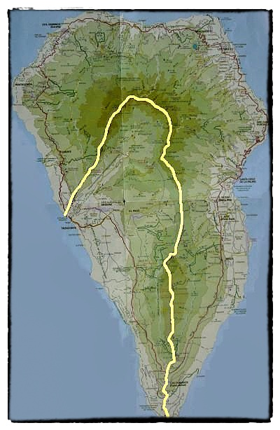
    General info: The route follows a natural ridge of the volcano that formed the island. It passes through national park, astronomical observatory and many volcanoes.

    The route can be done in 3 days. It's 63km but 3.794m of total ascent. Can be done throughout the year.

    Getting there: The island is small and there are plenty of bus routes. You can easily get to both ends of the route from Santa Cruz de La Palma and back.

    Remoteness: The route passes through "Roque de los Muchachos", highest point of the island and astronomical observatory. This point can be reached by car and is a popular tourist destination. Other than that I don't remember seeing anyone during the 3 days of hiking. The first/last town you pass through is Los Canarios, few kilometres from the start/end of the route.

    Water: No water. You pass through Punta de Los Roques shelter in about the middle of the hike. There is a water deposit there that is re-filled periodically but you cant really count on it. You have to carry water for the whole hike.

    Camping: As I mentioned there's a refuge that you could probably use when starting in Fuencaliente and going north. Walking the other way I passed next to it in the afternoon so I didn't sleep there. You can camp pretty much anywhere. It's legal to sleep anywhere in the mountains but you can only camp in designated areas during the day. Obviously don't start any fires.

    Dangers: Other then the remoteness itself - none. The route is well marked and safe.

    Overall: Highly recommended. It's a remote but well maintained route. Short but definitely on the difficult side. Climbing from a see level to the highest point of the island is a nice challenge. Great views from the top and volcanic scenery along the way make it all worth it.

    What else to do: La Palma prides itself in the quality of it's hikes and you will find plenty of other quality routes there. Short flight/ferry trip away is also Tenerife with Teide, highest peak of Spain.

    My setup (so far) (lemmy.curiana.net)
     

    Wanted to share my setup so far, in part to get some feedback, in part to share results of my own research.

    Hardware

    The base is an old Dell laptop with 8GB of RAM, nothing special.

    For network I got cheap (~30 euro) Cudy router compatible with OpenWRT. I looked at MikroTik but it was more expensive and the setup looked more complex. OpenWRT was very easy to install and fairly easy to set up. I really appreciate the firewall, I was able to easily cut off my smart TV form the internet for example. Setting up port forwarding was also easy.

    For storage I got Icy Box USB RAID, set it up to RAID 1. It was the cheapest solution I found and it works fine after a bit of fiddling (issues with the fan but it's a long story, can give more details if someone's interested because otherwise I'm happy with it). I use it for backups for now and plan on using it for slow storage in the future. I also got 5TB USB drive for media (arr). I don't care if I lose it so no backup or RAID here.

    No UPS so far. I'm planning on installing solar planes with battery which should protect me from power cuts.

    Software

    Proxmox as a base. I hesitated if I really need it as I was planning to setup 3 VMs only but in the end the ease of backups and storage management convinced me to use it. Works great, no issues here.

    VMs based on Debian.

    I'm using cosmos cloud to manage my apps (https://cosmos-cloud.io/). I compared couple of different solutions and this one had the biggest library of supported apps and uses docker (I like the additional security provided by containers). It works great so far and has all the features I needed.

    I chose netbird for VPN and I'm not happy with it. The Android app has serious issue with battery usage. It was reported long time ago and it's still not fixed. That's really sad because otherwise the app is great. I'm trying to switch to netmaker now. Why not tailscale? I don't want to tie myself to a closed source app like that.

    Backups

    VMs backed up by Proxmox daily, stored on the RAID and synced to external server (VPS with NFS drive).

    Network and VMs

    One internal server accessible only thorough VPN. It hosts *arr stack and bitwarden.

    One external server accessible through port forwarding in OpenWRT and nginx with fail2ban. It will host forgejo, my webiste and so on.

    One exit node VM running nord VPN.

    Phone with always connected VPN routing everything through the exit node.

    Bitwarden with self-signed cert imported on phone.

    Monitoring

    Simple monit scripts pinging individual servers, checking VPN status and status of hard drives.


    I've been running it for couple of months and so far everything is working great. I want to setup the external server next, test the backups and switch to self-hosted netmaker for VPN.

    Anything else I should do or anything I should stop doing?

    view more: next ›