1


Back to planning hikes close to home ⛰️I always recommend Val Di Zoldo, it's less crowded compared to other parts of the Dolomites, and it has amazing hikes as well.Whenever I need to step back from the crowded areas, it's always my first choice ❤️@hiking #hiking #dolomiti #dolomites #mountains

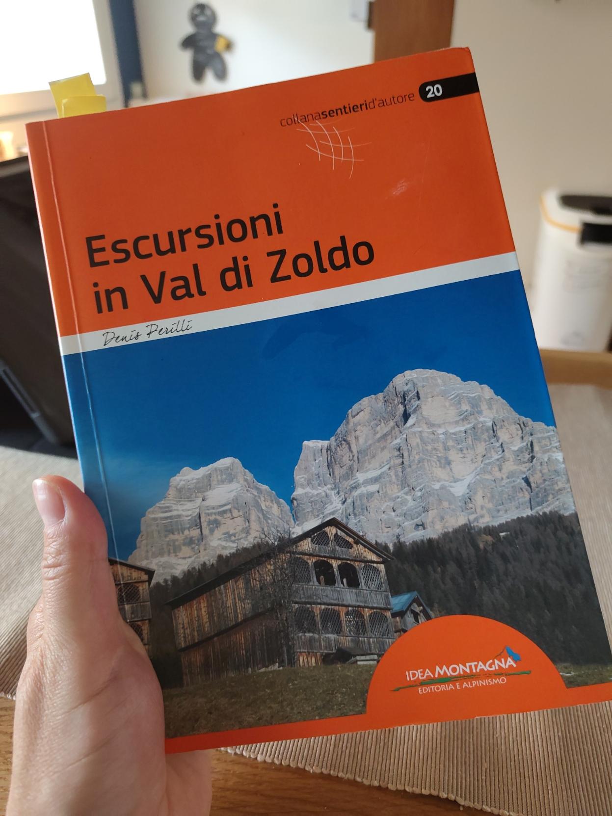
A hand holds an open book titled 'Escursioni in Val di Zoldo' by Denis Perilli, part of the 'collana sentieri d'autore' series. The cover features a striking image of snow-capped mountain peaks (the Pelmo mount) towering over a traditional wooden building with a balcony, set against a backdrop of dense green forests. The book is published by Idea Montagna, as indicated by the logo and text at the bottom right corner, emphasizing its focus on hiking and alpine exploration in the Val di Zoldo region.
2


Fresh off the heels of my last hike...

First, let's just say it's "in Europe" because it's best accessible from Europe...

Second, a huge disclaimer: everything I write here can very soon be outdated. With the construction of international Airport in Nuuk Air Greeland stopped operating flights to Kangerlussuaq. Current flights from Copenhagen are chartered by local tourist company and it's unknown if they will still operate next year. If international flights stop it's not clear if any civilian flights with operate there. On top of that the town responsible for the trail is trying to increase the number of tourists using it. A road linking Sisimut and Kagerlussuag is under construction. Currently it's only an ATV track but plans for proper road exist. So it's possible that completing the trail will be soon significantly more complicated, there will be more traffic there or that things will stay the same for couple more years. No one knows.

Basic details can be found here: https://arcticcircletrail.gl/

General info: It's a beautiful, 160-210 km trail. Lots of wildlife, great views...

Getting there: Currently you can fly from Copenhagen directly to Kangerlussuaq or to Sisimut through Nuuk. Sisimut offers additional connections with a ferry. Only one flight a week to/from Kangerlussuaq at the moment (on Wednesdays). Other connections and local flights exists as well.

Hiking time: The official estimate is 8-10 days. That's a lot for 160km so I wasn't sure what to think about it. As you can expect it's exaggerated. It took us 5.5 days to finish the part between Sisimut and Kangerlussuaq and we had plenty of time to rest, wait for better weather and stop at beaches. 7 days should be plenty. 8 is more than enough. That being said the terrain is difficult. There's a lot of mud and streams so you have to constantly look for best places to cross them without getting all wet. You will have to cross a river couple of times. It does slow you down so it will take more time than similar trails in easier terrain (for example West Highland Way is 154km and took me only 4 days).

Markings: the trail is pretty hard to follow. The current trail, old version of the tail, ATV road and official GPS track all run in parallel over some portion of the trail. Sometimes all of it overlaps, sometimes nothing does. It's easy to start following the very visible ATV road and miss the place where the trail diverts. When the terrain gets wet the trail splits into many different path that end nowhere. I would recommend following the GPS track.

Water: plenty but I would recommend filtering

Direction: 95% of people go from Kangerlussuaq to Sisimut. No idea why. We went the opposite way and passed most people over 2 days (because everyone comes in the same plane). Plenty of benefits of starting in Sisimut which I will mention in other sections.

Supplies: There's a big, well equipped outdoor store in Sisimut. It closes on 17:00 but if you're flight arrives later you can order online and ask them to leave your things behind the store. There are also couple of supermarkets there. There's a smaller outdoor store in Kangerlussuaq and one supermarket there (everything closes at 17:00). Of course nothing is available on the trail itself.

Remoteness: We saw about 30 people on the trail. It was clear a lot of people arrived on the same plane and hiked quite close one group after another. For about 2 days after leaving Sisimut we've seen hunters riding ATVs on the road parallel to the trail. Few ATVs left Kangarlussuaq so we couldn't see them later. No cell phone coverage on most of the trail.

Southern route: There's an alternative path that avoids the ATV road. It has some stone markings but not a clear path. We were told it can take up to 5 days just to finish the section where southern path diverges from the original trail. What would mean it takes about 3 days more in total than the northern route.

Huts: You will pass a hut or two every day. The huts are very different, from very simple ones fitting only 2 people to bigger ones, with multiple separate rooms. All of them have kerosene heaters but none have fuel. We spend 5 nights on the trail and we had one hut completely to ourselves, one hut we shared with one more person and we had a full room to ourselves in another one. The other nights we camped because the huts were full or we reached them to early in the day. As I said, most people from for Kangerlussuat to Sisimut and leave on the same day. Following this plan it will be hard to find room in any of the huts.

Canoes: Part of the trail traverses a 20km lake. This part can be done in canoe or on foot, bordering the lake. Canoes can be found at one of the huts at either end of the lake. Closer the Sisimut there's a big hut (Canoe centre) with 3 big rooms. If you're late all the canoes will be at Canoe Centre and you will have to wait for someone to cross the lake in other direction to get a canoe. Since 95% of people are going the same way it can take a lot of time. Starting the route in Sisimut pretty much guarantees you will have a canoe available.

Mosquitoes: we hiked in the second half of August and didn't have any issues with them. Apparently colder weather during the summer killed all of them and there's usually more of them on the trail.

Extension: Hiking from Sisimut you can skip Kangerlussuaq entirely and follow a trail over the mountains directly to the glacier. The route is really nice and well marked. It's not as remote (you will have some cellphone coverage and there's a road nearby) but there's still plenty of wildlife and great views. You can also go down do Kangerlussuaq, recharge and start the trail from there. You get 300 days of sunshine per year in Kangerlussuaq so weather on this part of the trail should be significantly better. You can camp right next to the glacier but it will be a bit colder during the night. Trips to the glacier and ice cap are organized from the town. Some people take them and stay at the glacier so they hike from the Glacier directly to Sisimut. If you go to the glacier you will have to hike back to the town on your own. This extension adds 50 km to the trail.
3


I live in Switzerland and until proven otherwise, I think we have the best cartography in the world. map.geo.admin.ch and the Swisstopo app are absolute treasures to plan hikes.

At the moment I am trying to plan a hike in France where I cannot use the swiss map. I have tried several layers of Openstreetmaps but I don't find any that seem as good to show the relief, the walking paths, public transport stops and type of terrain.

What is your go-to cartography option?

4
 
 
5


(When I was planning some of the longer hikes I often struggled to find the most important info for me. You can easily find GPS tracks but those don't really tell you what type of a route is it: How remote it is? Is there water? Can you find food? Where can you camp? So here are some of the routes I did and some basic info about them)

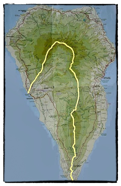
Starting with a bit more exotic option: GR 131 on La Palma island. Also called "El Baston" because it kind of looks like a walking stick.

General info: The route follows a natural ridge of the volcano that formed the island. It passes through national park, astronomical observatory and many volcanoes.

The route can be done in 3 days. It's 63km but 3.794m of total ascent. Can be done throughout the year.

Getting there: The island is small and there are plenty of bus routes. You can easily get to both ends of the route from Santa Cruz de La Palma and back.

Remoteness: The route passes through "Roque de los Muchachos", highest point of the island and astronomical observatory. This point can be reached by car and is a popular tourist destination. Other than that I don't remember seeing anyone during the 3 days of hiking. The first/last town you pass through is Los Canarios, few kilometres from the start/end of the route.

Water: No water. You pass through Punta de Los Roques shelter in about the middle of the hike. There is a water deposit there that is re-filled periodically but you cant really count on it. You have to carry water for the whole hike.

Camping: As I mentioned there's a refuge that you could probably use when starting in Fuencaliente and going north. Walking the other way I passed next to it in the afternoon so I didn't sleep there. You can camp pretty much anywhere. It's legal to sleep anywhere in the mountains but you can only camp in designated areas during the day. Obviously don't start any fires.

Dangers: Other then the remoteness itself - none. The route is well marked and safe.

Overall: Highly recommended. It's a remote but well maintained route. Short but definitely on the difficult side. Climbing from a see level to the highest point of the island is a nice challenge. Great views from the top and volcanic scenery along the way make it all worth it.

What else to do: La Palma prides itself in the quality of it's hikes and you will find plenty of other quality routes there. Short flight/ferry trip away is also Tenerife with Teide, highest peak of Spain.

6


Today we hike in the presence of the queen: the Marmolada.#MountainMonday #hiking #dolomites @hiking

A breathtaking view of a rocky mountain trail leading towards the majestic Marmolada, the highest peak in the Dolomites. The path, surrounded by rugged gray rocks and patches of green grass, winds its way through the alpine landscape. The sky above is a vibrant blue, dotted with fluffy white clouds, while the snow-capped summit of Marmolada dominates the background, creating a stunning contrast between the earthy tones of the foreground and the icy white of the mountain.
7


Ultima uscita in ambiente innevato con il CAI di Treviso, fatta il 3 aprile. Splendida, lunga, con una vista mozzafiato sulle nostre montagne e sulle Tre Cime di Lavaredo. Dopo questo itinerario immerso nella neve, si inizia a programmare per quelli estivi, in mezzo al verde che sta iniziando a fare timidamente capolino. 📍 Dolomiti di Braies: Carbonin - Monte Specie 🏔️ 20km, 860mt di dislivello, escursione in ambiente innevato, con ciaspole 👣 Percorso completo su Komoot https://www.komoot.it/tour/2860677723?ref=aso #hiking #dolomiti #escursioni #montagna #mountains #veneto #snow #trecimedilavaredo #dreizinnen @hiking@lemmy.world @hiking@fedigroups.social

Una spettacolare vista delle Tre Cime di Lavaredo, con le loro imponenti guglie rocciose che si ergono verso il cielo azzurro e limpido. Le cime sono parzialmente coperte di neve, e la luce del sole accentua le sfumature delle rocce, creando un contrasto con il bianco della neve sottostante. Il paesaggio trasmette un senso di maestosità e bellezza naturale, con le montagne che dominano l'orizzonte
8


Hey Everyone, I am planning a trip to Mt. Rainier this summer. I know some areas were closed a little while ago. To my knowledge, everything is back open, and I am looking for recommendations for campsites and trails to visit. If anybody has any info they can share!

9


Before anyone jumps on me about good boots being worth the investment I already have a quality pair of hiking boots (Danner Lights) but I'm going to be sending them out to be resoled soon, estimated turnaround time will be about 5-6 weeks, and I'm just looking for a temporary pair to hold me over for whatever hiking I do for the month or so I won't have my main boots. After which these temporary boots will probably go into the trunk of my car as part of my emergency kit to hopefully never be worn again.

Anyone got a favorite pair of cheap boots?

Small checklist I'd like to have:
Wide sizes
Waterproof
Lightweight (though I'm not expecting miracles on that front)
Preferably about a 6" height, I'm flexible on that, but generally I prefer a taller boot.

10


Howdy all. I have a 33% avg grade, highly overgrown slope (~450' length, ~160' elevation change) at the edge of my property that was originally used by a railroad company 130 years ago to slide trees down to where they were building railroad ties. It is now exclusively a deer path (the poo on my knees can attest to that) and I had to scramble at several points to get up.

If you were in my deer poo covered shoes (and assuming I had cleared all the brush and fallen trees), would you build trail stairs, e.g.

or a small set of switchbacks (space is tight as I have like 30' of width to play with), e.g.

orrrrr would you just clear it out well and deal with sprawling for a few steeper parts? (my least favorite option as I would like to hike this several times a week when it's done)

I'm concerned with long-term maintenance but am willing the put in the upfront work! TIA

11
12
13


Hi everyone! I’m exploring  emergency call experiences and rescue communication in mountaineering. The survey is anonymous, takes about 3–5 minutes, and is open to anyone interested in mountain or outdoor activities.🩷

🙏 Survey link with google form: https://docs.google.com/forms/d/e/1FAIpQLScJ3MoMgNQZz07ODtqm25sPpV-e99HZzDx__4Oe7BF-70sUcw/viewform?usp=header

If you have any experiment If you have experience in mountain activities, it would be helpful. Especially if you have experience with emergency calls, please be sure to participate in the response.

14


Just absolutely insane what this guy was able to pull off.

The 37-year-old climbed 403,740 feet, covering 629 miles on foot and cycling 2,568 miles between the peaks. He spent 489 hours in motion in those 31 days, linking all the publicly accessible 14ers in the lower U.S. On each stage of his project, the once-in-a-generation mountaineering legend was joined by high-profile local athletes who pedaled, climbed and ran alongside him.

15
Hiking in Jeans? (lemmy.dbzer0.com)


I'm in this hiking club and they were adamant about not hiking in jeans.

Now I know they're not the best pants but I said it should be fine to wear them on short hikes and it wouldn't kill you but there are better things to wear. They added in further they will kick individuals out for wearing jeans.

Now I personally have done many hikes, even longer hikes wearing jeans with no issues. I want to know your thoughts below on this topic. Am I in the wrong here?

16


tl;dw: among other issues, the network doesn't appear to store messages until they're confirmed to arrive, so it's very possible to miss incoming messages with no indication to either party

17
18
Let's hike BC! (lemmy.ca)
submitted 1 year ago by to c/hiking@lemmy.world


Moving to BC in October and would love to meet some hiking partners! Here’s a photo from CO because photos. Hit me up if you’re planning a hike and want some company

From the Redcloud summit, lots of little snowy peaks in the distance
19


I'll be off to the Azores in a few weeks. I've been looking online, but I can't find any English maps with scales that are usable for hiking (≤1:50k). The best I've been able to find are these:

  • 1:60k/70k in English

https://www.mapsworldwide.com/maps-charts-atlases-c1811/azores-tour-trail-super-durable-map-p41582

  • 1:50k in German

https://mapscompany.com/products/cartes-de-randonnee-acores-n-2260-kompass

20


I was hiking in a wilderness area...a very remote trail without a lot of action, and at one point I heard voices...I swore I heard human voices.

It was up in the mountains, too, so there wasn't much to make noise like that.

Obviously, I know it's my brain hearing trees groaning in the wind and quickly shortcutting to, "must be a human voice!" But it was just eerie.

21
22


Numerous hikers have been caught in a rockfall north of Lake Louise with multiple people injured or killed, according to the RCMP.

At around 1:30 p.m., Lake Louise RCMP were notified that "multiple hikers" were caught in a rockfall on a trail in the Bow Lake/Bow Glacier Falls area.

RCMP Cpl. Gina Slaney said the latest information available is that the incident involves "serious injuries and/or multiple fatalities," but she didn't have exact details as there is no cell service in the area and getting information from the scene is difficult.

23


AllTrails has a new generative AI feature that can be asked to 'shorten my route' or 'make this more scenic.'

But the people in charge of searching for lost hikers say the feature is going to exacerbate an issue they’ve been warning about for years: hiking apps providing false information."

(Reader mode shows the full article)

24


I hike with my dog about 5 miles every day. I recently started to use poles, which have been great for clearing debris from the trail, and fighting off unwanted attention from unruly dogs on the trail.

I have a pair of lightweight aluminum twist to lock collapsible poles, but after 12 days of use the twist lock mechanism failed on one.

I am looking for something that is going to be more sturdy. I do not need ultra light weight, as the initial thought behind using them was for an upper body workout while hiking. AMA having a little more weight to them should I need to use them as a club would be welcome.

Mostly I care about them being sturdy, and having comfortable grips.

25


Is there a more free version of Alltrails? I find Alltrails to be too paywalled when I don't even think they deserve my money. What exactly do they even do? The community creates everything and it's not like they're contributing to the Maps community or anything.

view more: next ›