post
Reminds me of this place:

(I remember just walking to school and it felt weird walking on a "slanted" street lol)
Old train tracks?
Sort of... its a subway... built over ground... right over the street... (colored lines are the subway)


Omg this is so nostalgic... just looking at the streetviews...
This was basically what "my world" looked like when my family first immigrated to the US...
At some point that was probably above ground. The reason many cities have these section not aligned is because they were aligned to the train tracks, not to a compass.
So you're saying that they were on the ground, but then they took it apart and built the little "bridge" thing so now it's above the street?
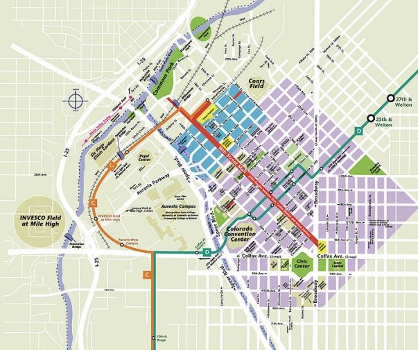
Downtown Denver:

This is the part in Sim City where I restart.
Aw, now I miss Sim City 2000
Sim City 4 is the best version of the Sim City games, and is 75% off on GOG right now, $5 / £4.
Cities Skylines 1 is the best modern city builder, 3D and a lot of fun plus well designed. But only really worth it when it's on sale; lots of DLC and overpriced as a package when not on sale. Avoid Cities Skylines 2 - it's just not fun and hasn't been fixed - maybe they will one day fix but I doubt it 2.5 years in..
Imagine what Cities Skylines could have been without Paradox's super monetization plan
The original developer has literally been pulled off of Cities Skylines 2. Maybe the little developer that Paradox put on it to crank out DLCs will do a good job and fix it, but I doubt it.
And don't forget the Network Addon Mod for Sim City 4. Improves traffic simulation and adds a whole bunch of new sorts of transportation stuff. It's really the expansion pack Sim City 4 never had.
Cities and Skylines isn’t too far off from that sim city 2000 vibe, if you need a fix
The GoG version of SimCity 2000 runs fine in wine. The originals, not so much.
https://appdb.winehq.org/objectManager.php?sClass=application&iId=504
I'll check that out! Thanks for the rec!
Just avoid cities skylines 2. It's just a cash grab
IMO the painful thing about it is that it was clearly just too ambitious of a simulation and they made it unmanageable, so then they backpedaled and made it too easy by having a lot of the systems automatically balance themselves (electricity from neighboring cities, for instance)
Yeah, Cities Skylines had traffic that was reactive to design. I've played some CS2, and while some things are improved (like lane connection), it feels like the traffic is just simulated sprites based on a traffic congestion variable for the area or something. Upgrading roads sometimes helps, but providing better routes doesn't always help like you would expect. It feels very disconnected and rewards linear progression rather than skillful or smart gameplay. I still play CS1 and I check in on CS2 once or twice a year to see if it still sucks. I did enjoy the bike patch to some degree, but the gameplay in general just seems artificial and lame. CS1 may be old with mediocre graphics, but it's still a 9/10 game in my opinion and you can buy in cheap nowadays to get caught up on DLCs and such. I have nearly everything except the radio packs. The menus are inconsistent and the way they organize things doesn't always make intuitive sense. I think they would be better off recreating CS1 on a more modern engine than trying to reinvent a masterpiece. For me CS2 was the biggest disappointment of the gaming decade. With that said, lots of games sucked on release. Fallout 76 grew into it's shoes, Stalker 2 was panned at release and is now much more highly regarded. I hope CS2 finds its way back into sync with the community, but I'll be enjoying CS1 and other games until that happens. Thankfully MS hasn't completely destroyed Minecraft. I practice city design on a much smaller scale on there (more "place making", less traffic management, more roleplay, less mechanics).
At least with places like Denver and other western cities it's pretty straightforward how it happened - everything built along the river. Access to the river was key.
Being a boom/bust city means that a much later boom they adjusted.
Then even older cities (think Boston) grew before any opportunity at planning could happen.
Denver was two cities - Auraria (correction from Aurora thanks to @negativenull) and Denver. One was built to align with the river, the other with compass points and then they grew big enough to smush into each other and neither was willing to concede to the other.
Also Denver’s namesake, a Kansas politician, never even visited. It was a failed attempt to lure him here.
(minor correction: Auraria was the name:
https://www.uncovercolorado.com/auraria-colorado-history/ )
I can't see the pic in your comment, but I am gonna guess Broadway and Lincoln between 19th and 20th?
Interestingly enough, Denver has 3 main grids:
The range and township grid as the typical NS/EW grid, the Araria grid by DU which is largely built over, and the downtown grid, the last two of which are aligned to Cherry Creek and the Platte River, though I'm not certain which one to which waterway. If it wasn't for one-ways, that area would be screwed up beyond belief. As it stands, it just looks a little odd and everyone needs to try to pick their lanes in advance. :D
Is this the most efficient way to store 17 houses?
Where is this?
Edit: Found it! Jacksonville Beach, FL
30.280765 N 81.393002 W
Jacksonville Beach, FL
https://www.openstreetmap.org/#map=16%2F30.27980%2F-81.39504
In my experience, many cities old enough in the US. Almost every biggish city where I live has the center of town laying differently than the newer, surrounding areas. There was a time when they oriented things different than how they plan it out now so now the older downtown areas look cock-eyed on a map/satellite image.
Grids were more efficient for pedestrians and unmotorized transport, but the caveat is that motorized transport, especially on large grids, will often be driving faster than is desired among the pedestrian traffic.
Which is why the ethos has changed off of grids to the windy, curvy roads that naturally encourage slower speeds...no straightaways to really build up speeds like you can with a grid.
Most town centers, which have likely existed before the car did in large numbers, are still laid out in a grid...but youll notice as you get farther out, when the neighborhoods started getting built in the post wwii era and the rise of the burbs, are not generally grids.
This is an easier way to eyeball how old a particular neighborhood is...with some caveats and exceptions of course.
A grid is still most efficient, but were trading efficiency for safety which is reasonable....weren't too many idiots doing 60mph on 35mph city streets like we have today.
A grid is still most efficient
May I introduce you to Magnasanti: No road grid. A map of mostly skyscrapers, libraries, and subway stations. https://youtu.be/NTJQTc-TqpU
“Sims don't need to travel long distances, because their workplace is just within walking distance. In fact they do not even need to leave their own block. Wherever they go it's like going to the same place.”
Reverse image search has mixed results... A few say Florida, but the top one says Wyoming. I'd guess the one that says Jacksonville, Florida is most likely.
I was thinking maybe an old Spanish Land Grant or something maybe. But, that doesn't seem to be the case. That block is orientated north, while the surrounding blocks are oriented parallel with the coast, just east (right) of the crop. So then, I thought that maybe it was one weird plat of lot and the city grew around it. Nope. The thing is, you can look up all the plats (thanks to Florida's sunshine laws) back to the original bureau of land management surveys (thanks to the BLM & labins.org).There aren't even that many. This neighborhood has been like this from it's beginning as far as I can tell. Around 1911 the whole town, then called Pablo Beach, was platted. And right there in the middle is this weird block, seemingly by design and without explanation. It was replatted in 1922, keeping the twisted block intact. It's been residential neighborhood and largely unchanged since then (at least as far as the parcels and streets are concerned).
Here's another one:

Missoula, MT
Inb4 Hank Green does a video about this.
It's actually a good story, too. I'm on mobile and not really qualified to tell it, however.
Two lawyers got in a pissing contest on developing the land they owned.
My great-grandfather apparently had a story about it. It involved lots of booze, a prostitute, and a horse. Then again most of his stories had the same theme so the truthfulness of the story is up for debate.
Missoula is a bit odd on a few things. I attended Hellgate elementary - yes that's the name of the school.
Indianapolis built the central mile square of streets aligned with magnetic north, but then the rest of downtown aligned with true north. It’s almost aligned, which causes problems at that border.
I've lived here for years and never realized that's why everything in the center looked slightly off center. Thanks!
How about a grid system that changes direction at every single avenue?

Speaking as someone who has been living in towns with rivers for most of my life:
This is the way.
My experience clearly says that you will loose orientation and get confused the moment you go to a district that is not alligned with the riverbank.
Looks like everyone started a new road perpendicular to the shore line, and the mess occurred when the roads got long enough to meet.
No they're were designed that way. The names remain the same no matter how many times they turn. The street i live on starts off going west, then south, then south west and back to west again on the other side of town.
Bingo. Allow me to introduce you to the colonial French seigneurial system.
Still a better system than Boston, having navigated both MANY times. To call Boston's streets a "system" is an insult to the very concept of order.
It's tough to look at, but I bet it's amazing for traffic calming.
The kinda shit I do in cities skylines when I get bored
Or cities skylines 2 because the grid system is shit and breaks if you sneezed in the last decade.
Is it still shit?
I was hoping it was going to do a No Man's Sky.
There's still some hope with new company but it really feels like a cracked gamble. I'll check back in September... again....
It’s getting much better. It’s not perfect yet. It’s not even as good as cities 1. But it’s much better than launch.
There has to be some interesting history here.
A few other examples have been posted, but this is easily the wildest. It's not even the same aspect ratio of grid, or at a normal angle to the rest, or over a very significant area. (And they've still managed to tie it in reasonably well)
To me what's wild about it is that it's completely filled with houses, and the houses seem to all respect the orientation of the nearest street.
You'd think that they'd say "Ok, well in this section we have these two roads coming at a narrow angle, let's just make this a park", or something to make the places where the two grids join a little less ugly.
I think that area was built when nothing else was there, without the developer thinking too hard about its orientation.
As time went on, new development started nearby, oriented to a different geographic element, like a shoreline, or a river, etc. eventually that development met the old development, and they were lined up differently, and the municipality stuck with the new grid system orientation and just built around the old one.
Yeah, someone deciding to clear out an area and develop it in a completely different way is possible, I guess, but seems a lot less likely. Maybe there's a bit of both - something large like horse stables or a hospital was there, then it was replaced with a new self-contained development, and then they built out into the margin around it later on yet.
In any case, somebody had a big urban planning idea of some kind, but it hasn't really continued to make sense as things changed. The angle could just be because one grid is aligned true north, and the other magnetic north.
Could also have been a remnant of say a grove or something and was simply developed later on. There's a couple of these type of things near me caused by my great grandfather being weird, where the streets are all fucked in their width because they're built on the old trails and roads. Sometimes the roads are only wide enough for a single car other times you could fit four next to each other with room to spare, also all the blocks are weirdly sized because they were built at slightly different times so are all oriented towards different cardinal directions.
I kinda like it. It's just neat enough.
A lot of old city plats follow the exact pattern of that square, so I'd be curious what the sequence of development was.
Unrelated but,
Theres a section of Prince George Canada that all of a sudden does a big U. The story i was told is that back in the day there were two competing railway companies, and one of them bought enough influence that when the city was making roads to the other company, they instead made the roads bend back. 


top 84 comments