1
Birthrights (birthrights-map.base44.app)


This is based on Richard Farson's Birthrights. Most maps are named after chapters from his book. It's come a long way since the last time I presented it a couple months ago and still has a ways to go, but I'm happy with how it's turning out.

I'm especially interested in feedback on the Right to the Night map. I'm intending for that one to be a guide that motivated youth can use to fight curfew legislation.

One thing that surprised me in the research I did for the project is that VT has no minimum age to run for governor. There's a 15yo on the ballot today and he's not even the first minor to run, so if you're in VT get out there and vote for Dean Roy.

Also happening today is the vote for allowing 16-17yos to vote in Culver City, CA. If you go to the cities part of the Political Power map, you can see the 16 cities nationwide that already have voting for 16-17yos.

I would imagine this project still works best on desktop, but if you have any feedback about the experience on mobile, that would also be welcome.

2
 
 
3


I recently learned about the Equal-Earth map projection. It seems to be the best balance for accurate shape and size of the globe in 2D. It was recently adopted by the UN to replace the Mercator projection.

4
 
 
5


Sikhism is the 5th largest religion in the world. The scriptures of Sikhism are the Sri Guru Granth Sahib, Sri Dasam Granth, and Sri Sarbloh Granth. Interactive map at https://agamsingh.me/gurbani-places-map/

6
 
 
7
 
 
8
9
 
 
10


This makes so much more sense

11


Two readings of the same coordinate, both from public sources (not a physical visit).

From the street: Centralia, PA looks like a town that was just paused. Asphalt intact. Double-yellow lines. Stop signs on all four corners. Power lines still up. No barricades. If you didn't know, you'd think everyone was coming back.

From above: the buildings are gone. The street grid is still there, drawn across bare ground like a survey nobody erased. And the stripped ground doesn't follow the streets. It follows the old coal workings underneath.

The fire started in 1962 in the borough landfill, on an exposed coal seam. It is still burning. The 2000 census counted 16 residents; the 2020 census counted 5. The ZIP code (17927) was revoked in 2002. The state bought and demolished the homes.

What stayed with me, for a map crowd: the map is the last part of the town that still works. The street grid is still a plan for a place that isn't there anymore.

Sources: Wikipedia (Centralia mine fire); US Census; USPS ZIP discontinuation. Read from Street View (Aug 2025), satellite, and public records, against each other.

12
[Microblog] RE: en (mastodon.green)


RE: en.osm.town/@seav/117372213490Even if you don't create maps follow along with #30DayMapChallenge for some inspiration and fun! Telling stories with maps. #histodons #mapping @map_enthusiasts @histodons @genealogy #genealogy

13
 
 
14
 
 
15
 
 
16
 
 
17
StoryMaps (doc.arcgis.com)


These articles feel like scrolling through infographics or watching a mini documentary. I really enjoyed "Urban Africa" but there are many others to go through.. Which one was your favorite and why? drop a comment :)

18


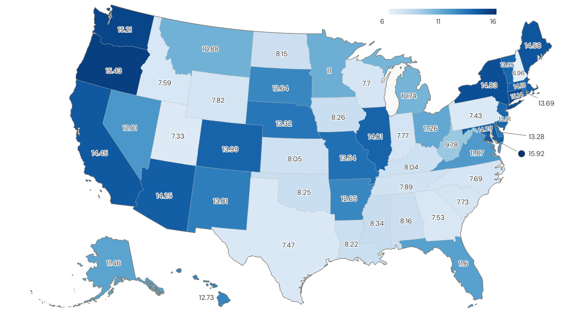
So it looks like your bang doesn't go tooo far for your buck even if you live in a LCOL state when you are on minimum wage I guess

Is this useful? What do you think? I honestly don't know, but seen that I already had the data from this discussion, why not plot it?

I tried to find a map with it, but my searching skills seem to have deteriorated (or search engines aren't great nowadays)

Data taken from St. Louis Fed's FRED (Federal Reserve Economic Data) for "Regional Price Parities (RPP): All Items" and "State Minimum Wage Rate"

Latest data available for RPP is 2024, so I used same date for wages. For states with no minimum-wage law or a minimum wage below the federal minimum wage, federal minimum wage was applied like the folks at Economic Policy Institute do

Convertion based on following formula:

real wage = nominal wage * (100 / RPP)

Plotted with ultimaps.com, if anyone has another alternative that shows data + state abbreviation, lmk

What flaws do you see on this map? Where does it fail? I guess metro areas are always complicated and a more granular approach with county data would be more useful, right?

19
CULINARY MAP (i.redd.it)
submitted 1 month ago by to c/map_enthusiasts@sopuli.xyz
 
 
20


Every dot is a place where a film or a series was really shot, taken from the filming location statements on Wikidata and from the filming sections of Wikipedia articles. 14,611 locations from 9,201 films and series, across 156 countries.

It is not complete and it is not meant to look complete. It holds what Wikidata and Wikipedia actually record, so India has 406 locations against an industry that makes more films than Hollywood, and about half the dots resolve to a town rather than to the exact spot.

I hope to add more points and items on the map. Free, no ads, no signup: https://thefilmmap.com/

A dark world map with every recorded film and television filming location drawn as a coloured dot, dense across North America and Europe, thinning across Africa and central Asia.
21
22


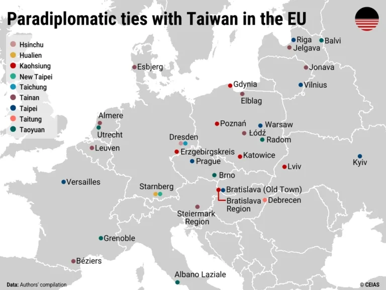
Source: Jun 2026 report from CEIAS (Central European Institute of Asian Studies): Sister cities, strategic gaps: Taiwan’s uneven paradiplomacy in Europe.

Via this post.

A few interesting tidbits from the report:

On the Taiwanese side, the most active cities are Tainan (nine European partners), Kaohsiung (7), Taoyuan (6), and Taipei (6). Hsinchu, Hualien, New Taipei, Taichung, and Taitung also maintain singular ties with local or regional governments in Europe. On the European side, Poland is the most active, with seven cities (Elblag, Gdynia, Katowice, Łódz, Poznań, Radom, and Warsaw) having partnerships with Taiwanese counterparts. This is followed by Germany, where three municipalities (Dresden, Erzgebirgskreis, and Starnberg) have as many as five ties to Taiwan. Paradiplomatic relations are also found in France (3), Latvia (3), Czechia (2), Lithuania (2), the Netherlands (2), Slovakia (2), Ukraine (2), Belgium (1), Denmark (1), Hungary (1), and Italy (1). The Nordic countries and Southern Europe remain notable gaps in Taiwan’s current paradiplomatic outreach.

For Taiwan, these paradiplomatic ties complement broader outreach efforts by creating an additional channel for international engagement amid constraints in the formal diplomatic system. They can create additional opportunities for engagement with European actors. Sister-city partnerships can facilitate cooperation with European local economies and governance networks through cooperation in areas such as innovation, the green transition, urban planning, or public health. Repeated exchanges and joint initiatives may also help normalize Taiwan’s presence as a capable partner, even if such cooperation remains politically sensitive in certain contexts.

(...) officials in many European cities operate under the impression that pursuing cooperation with Taiwanese partners may lead to boycotts by Chinese tourists and other forms of Chinese retaliation, which is one reason Edinburgh pre-emptively shelved a friendship agreement with Kaohsiung in 2024.

By contrast, other European cities, including Prague, have been more willing to absorb or dismiss such risks. In 2019, the city moved to terminate its sister-city agreement with Beijing over a dispute concerning the “One-China” clause and, in 2020, signed a new partnership with Taipei. The move triggered a series of retaliatory measures from China: Shanghai canceled its agreement with Prague, Chinese authorities blocked or discouraged Czech cultural performances and tours in China, and Chinese officials issued repeated diplomatic warnings to Czech counterparts. Despite these actions, Prague not only maintained but further deepened its engagement with Taiwan, suggesting a willingness to absorb reputational and diplomatic costs in pursuit of a values- and interest-driven partnership.

The Pact was established in 2019 by four Central European capitals—Bratislava, Budapest, Prague, and Warsaw—to share best practices in urban development and municipal governance, as well as to resist illiberal and populist practices of their respective central governments. Since then, the regional platform has expanded to cover municipalities across Europe, such as Berlin, Paris, Riga, and Vienna, and across North America, including Los Angeles, Boston, Seattle, and Chicago. It currently boasts 45 members. In 2021, the Taiwanese cities of Taipei and Taoyuan became the Pact’s first, and so far only, members from East Asia.

Solidarity with Ukraine, and parallels between Russian aggression of the country with potential future invasion of Taiwan by China, has also sped up engagements between Taiwan and Ukraine. Even if Ukraine’s central government remains wary of official contacts so as not to spur even more Chinese support for Russia, on the subnational level relations are taking off. Taipei and Kyiv signed a cooperation memorandum in 2023, while Lviv and Kaohsiung established ties in 2025.

A map of Europe highlighting cities in paradiplomatic relationship with their Taiwanese counterparts. The highest concentration is in Poland.
23


Source from 14 May 2026. I haven't checked if any new IPAs or Key Biodiversity Areas have been established after this date

Proponents of Indigenous Protected Area (IPA) say they can empower Indigenous Australians as decision-makers in land management, combining traditional ecological knowledge with conservation goals.

IPAs now account for 54% of Australia’s progress toward protecting 30% of its territory by 2030

While research shows every $1 invested in IPAs yields up to $3.40 in social, economic and environmental returns, advocates stress that Indigenous communities still need meaningful, sustained support.

[...]

O’Leary of Country Needs People acknowledges the system isn’t perfect, and says successful IPAs rely on careful planning, support and engagement. But, he says, they represent a critical tool that’s being used right now.

“Yes, there are a lot of things to be improved,” he adds. “But this is happening on the ground now in real time. It’s not being theorized in academic papers or in international forums alone. It’s actually happening on the ground for people, and that is where the rubber hits the road.”

24


Nations that have banned paraquat in white

Source from Feb, 2026 by EWG (Environmental Working Group). If anyone has a more updated version, feel free to share it

Notes:
Myanmar:

From 1 April [2026] onwards, paraquat will no longer be permitted to be registered, imported, sold, formulated or repackaged in Myanmar

Canada:

In Canada, Syngenta was the only paraquat manufacturer with a registered product. Syngenta discontinued registering its product in Canada in 2023 following updated risk-mitigation efforts. Although there is not an outright ban, no paraquat products are sold in Canada.

India:

The draft 'Banning of Paraquat Dichloride Order, 2026', issued by the Ministry of Agriculture and Farmers Welfare, was published in the Gazette of India on July 13 and will remain open for public comments for 30 days before a final decision is taken. Did it pass? I cant find much on it

In the USA before California's ban a couple of days ago:

25
 
 
view more: next ›