all 78 comments

sorted by: hot top controversial new old
[–] 118 points 1 year ago (11 children)
  • [–] 5 points 1 year ago

    Dymaxion.

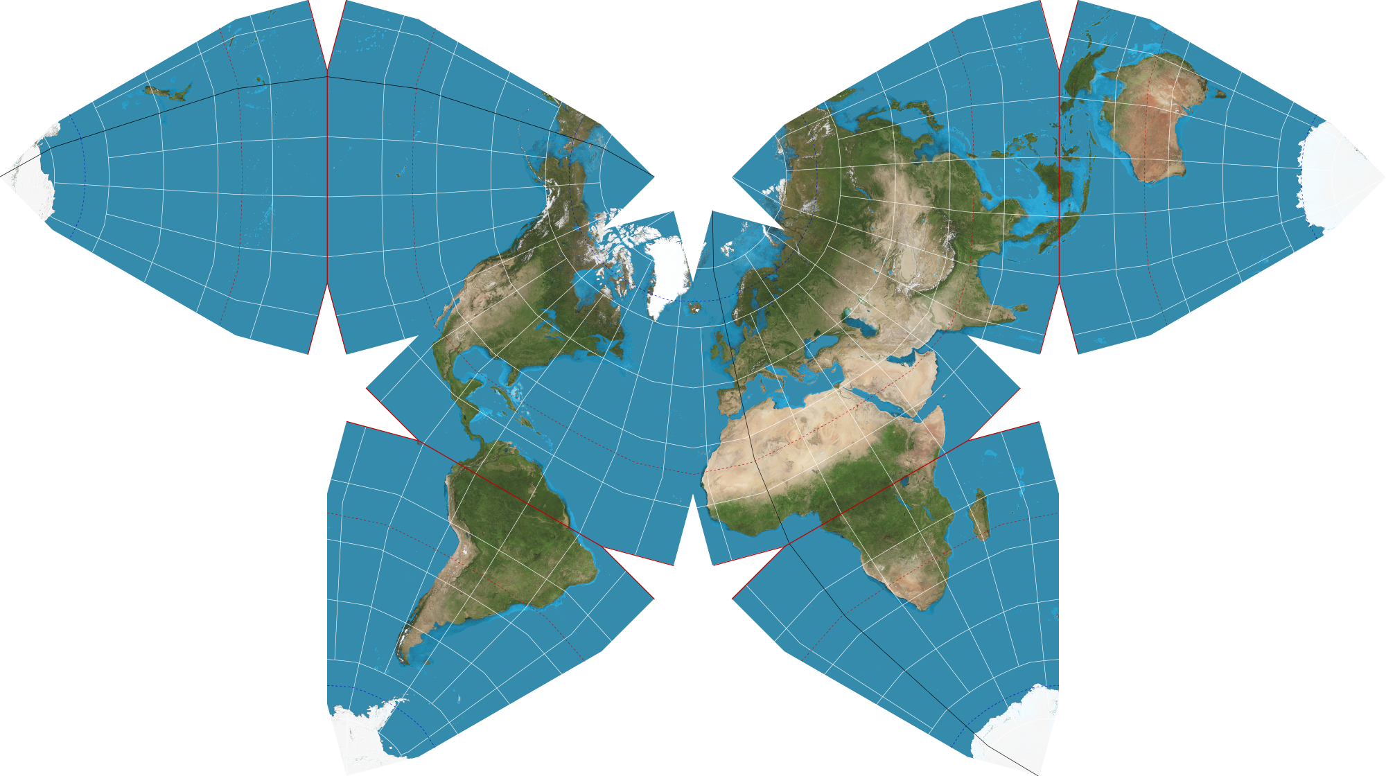
    Waterman is nice and all, but I don't like the way it splits Australia and New Zealand, or how it puts Antarctica in a separate bit like Alaska in USA maps.

    Dymaxion offers a nice continuous view of all the continents, and can still be folded into a sufficiently spherical globe-like thingy.

    It'd be nice to have an alternative version that made the oceans continuous, though, for people who like ships and stuff.

  • source
  • parent
  • I feel like it's missing a style I don't know the name of but can describe. Basically a map made up of 4-6 parts depending on it they want the north and south poles wherein it shows the earth at 4 different point roughly broken up by continents, Europe and Africa, Asia and parts of Oceania, Oceania, and North and South America.

  • source
  • parent
  • [–] 82 points 1 year ago (9 children)

    “It’s [the Mercator projection] the world’s longest misinformation and disinformation campaign, and it just simply has to stop.”

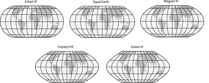
    No matter how we cut it though, all 2D projections will have some kind of distortion. They opted to preserve area, while the Mercator preserves angles. Arguably it is less important today to preserve angles, as we have automatic navigation systems. There are some alternatives that also preserve the area: https://upload.wikimedia.org/wikipedia/commons/7/76/The-Equal-Earth-compared-to-similar-equal-area-pseudocylindrical-projections.png
  • source
  • hideshow 9 child comments
  • [–] 27 points 1 year ago (2 children)

    Right. What people need to understand that any globe put on a flat surface will be distorted. Their proposal is just as distorted as the Mercator, just in area vs angles as you stated.

  • source
  • parent
  • hideshow 2 child comments
  • [+] -13 points 1 year ago* (last edited 1 year ago) (4 children)

    The Mercator is a propaganda campaign to make Christian countries look big and powerful. Ask yourself why is it only “Christian” countries that are distorted.

    Edit: should have put this /s

  • source
  • parent
  • hideshow 4 child comments
  • [–] 17 points 1 year ago

    Maps were used for navigation, which meant angles needed to be preserved. Christian nations colonised a lot, meaning they needed to have maps for navigation a lot too.

    This isn't some weird propaganda campaign, that makes no sense. Try making an angle-preserving map that doesn't wildly distort the north and south of the world.

    Besides, not sure how Christian the icy wastes of Greenland and Antarctica are.

  • source
  • parent
  • [–] 27 points 1 year ago* (6 children)

    We should encourage the use of more globes to represent world maps.

    Like, seriously. Almost all maps are viewed on a computer screen, all computers easily have the ability to display a sphere and rotate it

  • source
  • hideshow 6 child comments
  • [–] -2 points 1 year ago (3 children)

    can't hang a globe on the wall

  • source
  • parent
  • hideshow 3 child comments
  • [–] 8 points 1 year ago (2 children)

    Just use a string and two thumbtacks, it's not rocket surgery.

  • source
  • parent
  • hideshow 2 child comments
  • [–] 20 points 1 year ago (3 children)

    The simple fact is no map projection will be perfect or do anyone "justice".

    You're flattening out a sphere to a flat rectangle. A lot of compromises have to be made. So go with the one that functions best for navigation.

  • source
  • hideshow 3 child comments
  • [–] 3 points 1 year ago

    Some projections are better than others. The Mercator projection at least has a use case that justifies its creation. This map has no purpose other than a political one.

    Everyone with a cursory knowledge of maps knows there are inherent issues protecting a 3d object into a 2d surface. That's fine because some projections are useful

  • source
  • parent
  • [–] 7 points 1 year ago

    I think equal area maps make a lot of sense, but the one I’ve seen promoted in the past as “fair” is the Peters Projection which is quite frankly trash.

    It was designed to preserve angles at the equator, and as a consequence all the shapes at higher latitudes are badly squished in the vertical.

    If there has to be distortion to preserve areas, it should squish in both dimensions and try to optimize shapes around the middle latitudes.

  • source
  • [–] 11 points 1 year ago (3 children)
  • [–] 5 points 1 year ago

    Gerrymappering.

  • source
  • [–] 5 points 1 year ago

    This is truly the concern of our time.

  • source
  • [–] 4 points 1 year ago

    Me when someone calls my pp smol

  • source
  • [–] 7 points 1 year ago (2 children)

    Like completely, or just as a default?

    It's uniquely the best option if you like using compass bearings.

  • source
  • hideshow 2 child comments
  • [–] 1 point 1 year ago* (1 child)

    Which, at a global scale, is important in your life when exactly? The only time I move at a global scale I'm flying, and then the projection makes it look like my pilot doesn't know how to fly in a straight line.

  • source
  • parent
  • hideshow 1 child comment
  • [–] 1 point 1 year ago

    Since the advent of widespread GPS, a lot less. It's historically interesting, and is still used as a backup by some ships, but it's not really necessary the way it was in the age of sail when it became the projection.

    Again, if they just want to switch to something more balanced as a default when you just want to point at things on a map, that's entirely reasonable.

  • source
  • parent
  • [–] 14 points 1 year ago* (7 children)

    I'm going to be honest, this just looks utterly useless for any country that isn't south africa, and ESPECIALLY useless for any country in the northern hemisphere.

    Like, yes, sure, you've made all the country's areas roughly equal, but also every single country that isn't south africa is a distorted, warped mess that looks nothing like its actual shape.

    Look at parts of europe- every country is a COMPLETELY USELESS shape. Three quarters of them have been turned into diagonal lines. How the fuck is that useful? Europe is the worst area in that regard, but by no means the only one.

    It makes it literally useless as a map.

  • source
  • hideshow 7 child comments
  • [–] 13 points 1 year ago (2 children)

    Every country looks distorted and warped based on your lifetime of experience looking at mercator projection. Every country looks warped and distorted when compared to globes. We learn geography on a flat surface which is inherently distorted because we live on a round surface

  • source
  • parent
  • hideshow 2 child comments
  • [–] 12 points 1 year ago (1 child)

    Actually, fun fact, the entire point of the Mercator projection is that it DOES maintain shapes/angles, just not scale. It's a nautical map, it's for sailing. That's why when you look at a mercator map and a globe, the countries look about the same, just potentially different sizes- because that's literally the point of it.

  • source
  • parent
  • hideshow 1 child comment
  • [–] 0 points 1 year ago

    Not exactly it distorts shapes a lot. However if you pick point A on a coast and point B on a different coast the angle of the line is the heading you should sail to go from point A to point B.

    So yeah very useful as a nautical map if you want to navigate from place to place. Not accurate in shape though.

  • source
  • parent
  • [–] 3 points 1 year ago (3 children)

    Who actually uses it as a map though? It's usually only seen briefly in apps, or in various symbols, or on a classroom wall. As a symbol, having the rights sizes would be a significant improvement. In an app, people will zoom in anyway, so at least they'd passively see the correct proportions when zooming out, instead of getting a false impression. In a classroom, it would seem all that more importantly to not give false impressions to kids.

  • source
  • parent
  • hideshow 3 child comments
  • [–] 0 points 1 year ago (2 children)

    The problem with that is that it gives a completely incorrect idea of what an individual country looks like, in a way that gives a false impression to kids about what the countries even look like. Suddenly they have to look at one map, and recognize a country, and then look at a zoomed in, more accurate map, and recognize it in a completely different shape. To be frank, most people's geography knowledge is already bad enough- doubling the amount of shapes they need to learn is basically a non-starter.

    For classroom instruction, a globe should be being used anyway- that's the gold standard. Why go through all the work and effort of introducing a worse solution, that doubles the amount of studying, and is made completely useless when it can be replaced by a $10 globe?

  • source
  • parent
  • hideshow 2 child comments
  • [–] 1 point 1 year ago (1 child)

    Is learning the shapes of countries really all that important? I would have thought by the time the shape matters, you're looking at/learning the details of the country, at which point you're not looking at a map of the entire world anymore anyway.

  • source
  • parent
  • hideshow 1 child comment
  • [–] 1 point 1 year ago

    Yes? The shapes of countries- and their relation to other countries around them- is literally the most important part of learning geography in some respects, because of how much that shape is influenced by- and has been influenced by- the surroundings, the socioeconomic and sociopolitical history, etc etc.

  • source
  • parent
  • [–] 3 points 1 year ago

    I always that that countries made their own maps and always centered themselves on it.

  • source
  • [–] 3 points 1 year ago

    Reminds me of the West Wing episode with the Petersen (?) projection map. Although I seem to remember that map format was under copyright and would have required a fee for every use. An intended consequence?

  • source
  • [–] 6 points 1 year ago (5 children)
  • [–] 3 points 1 year ago (2 children)

    It was very much a real discussion back then as well. The writers didn’t invent this argument.

    People have been complaining about maps in general since we first started making them. The Gall-Peters projection that they mentioned traces its origins back to 1855 when James Gall first introduced the concept.

    In the 1970’s, Arno Peters made this projection well known. He specifically argued the point the show makes: other maps distort our perception of the world and it fosters problems with how we treat some countries.

    https://en.m.wikipedia.org/wiki/Gall%E2%80%93Peters_projection

  • source
  • parent
  • hideshow 2 child comments
  • [–] 1 point 1 year ago (1 child)

    I was honestly not aware. Learn something new every day!

  • source
  • parent
  • hideshow 1 child comment
  • [–] 2 points 1 year ago

    You’re welcome, enjoy your odd new fact :D

    Stuff like this is why I really enjoy The West Wing. It often has interesting real world arguments that it plays out smartly. A bit too optimistic in our current political climate, but still fun to watch.

  • source
  • parent
  • [–] 4 points 1 year ago (3 children)

    Looking at the correct map makes it clear that our Risk Continent Troop values need updated now.

  • source
  • hideshow 3 child comments
  • [–] 5 points 1 year ago (3 children)

    Ok come up with something that's better and just as practical.

  • source
  • hideshow 3 child comments
  • [–] 6 points 1 year ago (2 children)

    They did. They are specifically advocating for the Equal Earth projection.

  • source
  • parent
  • hideshow 2 child comments
  • [–] 7 points 1 year ago (1 child)

    I mean everything is approximately to scale i guess, but the further east or west you get from Europe/Africa the more bent things get. Including the area that 75% of the worlds population live.

  • source
  • parent
  • hideshow 1 child comment
  • [–] 6 points 1 year ago

    Well yeah, every map projection has to mis-represent something. In this case they're arguing that presenting area is more important than presenting angles. Outside of long-distance travel on ships and planes, which are not using general-purpose world maps, nobody is navigating with a world map, so I think that they're probably right here. It seems more important to me to understand the relative size of Africa to other landmasses than it is to know that the Korean peninsula is actually a few degrees off of being straight north of Borneo

  • source
  • parent
  • [–] 2 points 1 year ago

    I personally think that Eckert IV is a little more visually pleasing while otherwise achieving all the same benefits as Equal Earth, but both are good

  • source
  • [–] 2 points 1 year ago (5 children)

    16th century? Huh I would have expected a far more accurate version would have been made and accepted long ago.

    Especially since during all the centuries since then accurate navigation was needed, even around Afrika, and not make journeys last far longer by keeping an incorrect map.

  • source
  • hideshow 5 child comments
  • [–] 29 points 1 year ago (4 children)

    Nautical navigation is where the Mercator map is actually the most useful. Any straight line drawn in it stays true and any angles are preserved. That's why every nautical chart is done using a Mercator projection. It's just not so great when blown up to the size of the world, but that was never really it's intention.

  • source
  • parent
  • hideshow 4 child comments
  • [+] -17 points 1 year ago (3 children)

    It was intentional as propaganda. During the Cold War, it made the U.S.S.R. look bigger and more of an imposing threat to the west.

  • source
  • parent
  • hideshow 3 child comments
  • [–] 12 points 1 year ago (2 children)

    It was intentional as propaganda. During the Cold War,

    Nope. It is hundreds of years older that that.

  • source
  • parent
  • hideshow 2 child comments
  • [–] 1 point 1 year ago (1 child)

    That's why I use the dymaxian projection

  • source
  • hideshow 1 child comment
  • [–] 1 point 1 year ago

    This is like that one American Dallas county commissioner, William Price, getting offended it's called Black Hole.

    The notion that projections perpetuate some racial agenda is exactly the pseudo-intellectual victimhood that takes away oxygen in the room for actual issues to be addressed.

  • source
  • 8 comments in c/news@beehaw.org view that post
    [+] 24 points 1 year ago (1 child)
  • [–] 5 points 1 year ago*

    True, but there are projections designed to compromise multiple factors, whereas Mercator Al has a specialized use case, so it's easy to agree that it's a poor layman/general projection

  • source
  • parent
  • [–] 5 points 1 year ago (1 child)
    [–] 5 points 1 year ago

    If they're really concerned with how big they look on a map, they should advocate for the Madagascator projection.

  • source
  • [–] 4 points 1 year ago* (last edited 1 year ago)

    Well, modifications to Mercator world maps are not a bad idea, people genuinely don't understand the size differentness (both ways - equatorial ppl how smol northern & southern territories are & the other way around, eg Europeans how big most of Africa is in comparison).

    The bad part of normalising anther type of sphere projection for this purpose is that it almost certainly wouldn't follow just one simple rule like Mercator's. And with that exact predictability actually diminished in a way.

    Eg, we could try to keep countries as close to the same-ish size & in return shrink (or have gaps in) oceans. Or keep smaller gaps between counties/some squares. Or have several different projections merged into one global map. Etc.
    All of it is always arbitrary.
    The true answer is only education (not necessarily, but preferability in early school days).

    wiki/Waterman_butterfly_projection:
  • source
  • [–] 1 point 1 year ago

    I vote for the Waterman Butterfly Projection

  • source
  • [–] 1 point 1 year ago

    Mercator is a good projection for navigation for a variety of reasons. It should never have been used for geology classes in schools, but I think what originally happened is schools would just buy a nautical chart and put it on the wall.

    Even when I was at school long before that episode of West Wing, my classroom had a Robinson Projection map, so the whole controversy seems like something that was ginned up possibly decades after Mercator was no longer in use except where it's needed.

    That being said Google used a broken version of mercator on their maps for many years..

  • source
  • 2 comments in c/hackernews@lemmy.bestiver.se view that post
    [–] 3 points 1 year ago (1 child)

    The flat earth society will hear about this around the world.

  • source
  • hideshow 1 child comment