1
posts
2
3
4
5
6
7
Solar and wind generation meet record 80% of power demand on Australia’s national grid
(www.theguardian.com)
8
9
Trump's Beef Tariff Plan Protects the Largest Driver of Global Deforestation
(www.greenqueen.com.hk)
10
11
12
13
Inside an Elder’s fight to save salmon habitat around a W̱SÁNEĆ village site from a highway
(indiginews.com)
ZȺWIZUT (Carl Olsen) speaks to supporters in SELEt₭TEȽ, a former village site and river. Today they are encompassed within Goldstream Park. Photo by Julie Chadwick
This story is a collaboration between IndigiNews and The Narwhal.

The sound of cars passing is a constant hum, so constant it’s almost meditative. Every so often one bleats out a honk of support.
On the shoulder of the highway stands a 78-year-old man, holding a sign that reads: “Save the Salmon.”
Cheeks ruddy from the cold, he clutches it with gloved hands from behind a waist-high concrete highway barrier.
His dark eyes glitter warmly behind glasses, and over his knitted wool toque is a black baseball cap emblazoned with the image of a tree, water and paddles.
This is ZȺWIZUT, a Tsartlip First Nation Elder also known as Carl Olsen.
Carl Olsen protests beside the highway in his homelands late last year. Photo by Julie Chadwick
For the last three years, he’s been coming out here every Tuesday — through rain, snow and even sickness — to stand out on the shoulder of the Malahat highway and protest.
It’s Dec. 30. ZȺWIZUT grins, surrounded by supporters who wave at cars and shake their own homemade signs.
Carl Olsen speaks with supporters outside Goldstream Park. Organizer Christine Willes, right, holds a salmon cutout designed by renowned artist Roy Henry Vickers. She said the highway protests have been a ‘transformative’ experience. Photo by Julie Chadwick
But it wasn’t always this way. When he first started out, it was just him, his granddaughter and a supporter from the local book club ZȺWIZUT runs.
At his back is Goldstream Provincial Park, or as ZȺWIZUT knows it, SELEt₭TEȽ.
At 477 hectares, it’s bigger than “New York City’s” Central Park, a verdant gem on the southern tip of “Vancouver Island,” just a 20-minute drive from the province’s capital.
The park features waterfalls, Garry oak meadows, 600-year-old Douglas fir trees, flowering dogwood, western red cedar trees, Oregon grape and salmonberries.
READ MORE: ‘Like going back in time’: W̱SÁNEĆ people to regain rightful ownership of abundant remote island
In front of ZȺWIZUT is the Malahat, a busy two-lane highway that cuts through the park and sees an average of 25,000 vehicles a day pass by.
The park’s accessibility means more than 600,000 people visit each year to camp, hike and hang out.
Many come in the fall to watch the huge runs of chum, Chinook and coho salmon that return each year to spawn in SELE₭TEȽ‘s waters.
The park’s chinook and coho salmon spawning habitat runs the length of the Goldstream River, from the downstream hydro dam to the river delta at Finlayson Arm. Photo by Julie Chadwick
Highway versus habitat
What prompted ZȺWIZUT to go out there in the early months of 2023 was learning of a proposal put forward by the province to widen the Malahat.
Critics say it would catastrophically affect the adjacent Chinook and coho salmon spawning habitat in SELE₭TEȽ.
According to the province, the highway expansion, estimated in 2024 to cost $162 million, was needed to improve safety and reliability along a 1.7-kilometre section that bisects the park.
One part that especially concerned ZȺWIZUT was the expected “permanent loss or alteration of aquatic salmonid and amphibian habitat” in SELE₭TEȽ.
This impact and others were detailed in a 139-page environmental assessment report commissioned by the province and completed in 2024 by consulting firm McElhanney.
The area’s chinook and coho salmon spawning habitat falls directly within the project’s footprint.
Within a half-kilometre of the project site, at-risk species were likely to be affected, including western screech owls, northern red-legged frogs, wandering salamanders and the endangered sharp-tailed snake.
Expand that to within five kilometres of the project site, and that list lengthens to at least 200 endangered and threatened species potentially impacted.
READ MORE: In W̱SÁNEĆ territories, Matriarchs raise funds to buy back their unceded lands
ZȺWIZUT was also horrified to learn that, among a host of other environmental issues, more than 700 trees would also be removed from an area along the highway during construction.
He thought about the owls and nesting birds, about the spe’uth (bears) that make their homes in SELE₭TEȽ and fed beside him while he and other nation members harvested fish for winter.
He thought of how the noise and vibration from excavation and rock blasting might affect the vulnerable salmon fry, hiding out in the darkness under fallen logs in river pools until they were big enough to head to the ocean.
“The canopy that creates the coolness of the water in the stream — if that disappears, those fish will disappear,” he says, “because then the water starts to get too hot. It’s about 12 degrees difference from the sun to the shade.
“So that’s what started me. I thought, ‘Yeah, I can do this. I can be the voice for the salmon.’”
ZȺWIZUT (Carl Olsen) protests expansion of the Malahat highway in SELE₭TEȽ, today the site of Goldstream Park. Photo by Julie Chadwick
Prayers, tea, and bearing witness
Every Tuesday for the last three years, ZȺWIZUT wakes up at about 5 a.m. in the house his grandfather built, on the W̱JOȽEȽP Tsartlip reserve.
He heads down to the beach right outside his door on the “Saanich Inlet” and starts his day with a prayer at the water’s edge.
“I meditate about what I would like to see in my day,” he says.
READ MORE: With court win, Quw’utsun Nation sees a ‘spiritual homecoming’ after 150 years
After his prayer, ZȺWIZUT heads to a local cafe for some toast and tea.
That’s typically where a group of supporters show up to tag along with him to SELE₭TEȽ. Others meet him there.
Some are members of local churches and the Wilderness Committee, or participants in his Indigenous authors book club.
One of those book club members is Christine Willes, a settler from a group called Goldstream Protectors that helped organize a protest with ZȺWIZUT and others at the legislature last October.
“What he says to anybody who asked him is, ‘Well, I can go and stand by the side of the highway,’” she says.
“And that’s what he says to other people. ‘Do what you can.’ So I thought, well, I can go stand on the side of the highway too.”
Much more than a roadway
For ZȺWIZUT, this fight is now much broader than the highway project.
It’s a flashpoint in a larger and contentious discussion around Indigenous land rights, title and reconciliation that has consumed the province — and has repercussions for the entire country.
It’s also about the ability for Indigenous people to make land decisions in their own territory.
To the W̱SÁNEĆ people — of which Tsartlip are a part — SELE₭TEȽ is one of their oldest fishing villages.
It was arguably protected by a treaty put to paper 174 years ago which clearly states they retain the rights to their village sites, and to hunt and fish on those lands as they always have.
The original North Saanich treaty, shown here in a glass case, is kept in the B.C. Archives in Victoria. Photo by Julie Chadwick
It’s one of 14 treaties negotiated in the 1850s by James Douglas, then-Governor of “Vancouver Island,” with the local First Nations.
For many, the existence of these treaties may come as a surprise, as it’s well known that most of the province’s land mass was never ceded by its original inhabitants.
READ MORE: Treaty-protected sxwayxum village site returned to Snuneymuxw: ‘Where our people have lived for thousands of years’
Known collectively as the Douglas Treaties, multiple court cases since the 1960s have re-affirmed these treaty-protected rights, for both the W̱SÁNEĆ and the other nations on the island who signed them in the 1850s.
This fight to hold colonial governments to their word is what has kept ZȺWIZUT out on the highway for three years.
This is another Douglas Treaty in the B.C. Archives, known as the Snuneymuxw Sarlequun Treaty of 1854, from the Nanaimo area. Its ‘signature’ sheets are not accompanied by a Douglas form. It consists only of a six-page list, in ink, of 159 names under the heading ‘Sarlequin Tribe’ with a note at the top in pencil. Photo by Julie Chadwick
‘It rightfully belongs to us’
On its website, the province states “Goldstream Park” was “given to the people of British Columbia by the Greater Victoria Water Board in 1958.”
But the actual history is far more complicated.
“It rightfully belongs to us,” stated Jean Baptiste Paul, a Tsartlip First Nation member and son of then-chief Thomas Paul, in an article published in the Daily Colonist on March 27, 1956.
“We have never given it up, and never been offered anything for our fishing and hunting grounds there.”
Jean Baptiste recalled how he had hunted and fished at SELE₭TEȽ as a child.
He told the Daily Colonist that all of the inlet, from “Cherry Point” to the hills south of SELE₭TEȽ, was Indigenous territory. It had been identified as such by his grandfather, former Tsartlip Chief Ben Paul.
Tsartlip and Malahat members had built fish-smoking shacks near the river and his grandfather had also constructed a log cabin in the area.
But one day when no one was there, all the buildings were burned down, Paul told the paper.
READ MORE: Historic land agreement ‘will bring our people home,’ says SC’IA⁄NEW Chief
At the time, Paul’s resistance was reported as little more than a passing curiosity with headlines such as, “Prospect of city giving park to B.C. has West Saanich Indians on warpath.”
In 1958 the province went ahead and designated the area a park in celebration of the province’s centennial.
SELE₭TEȽ became a tourist attraction. Even though it was not yet officially open, the campground was quickly packed with vacationers.
Newspaper columnists sung the praises of its beauty and touted its quick accessibility from “Victoria.”
In the fall of 1960, thousands of onlookers crowded around the waterway to watch the salmon run, a practice that continues to this day.
WEC’KINEM (Eric Pelkey) is hereditary chief of the Tsawout First Nation. Photo by Julie Chadwick
A host of new problems
However, these thousands of new visitors brought with them a host of new problems, says WEC’KINEM (Eric Pelkey), hereditary chief of the Tsawout First Nation.
Sometimes when nation members are down at the river harvesting fish, visitors to the park will confront them.
“They start cussing us up and down, saying that we’re destroying the fishery,” WEC’KINEM says. “We tell them we have the right — we have the right to do this, to carry on our fishery and to just leave us alone.
“But there’s still a lot of racism that comes out at that time. People think we’re torturing the fish.”
The W̱SÁNEĆ carry on regardless. More recently, people have also been coming out there to support them, he adds.
WEC’KINEM sits at a picnic table in the park, the gentle rush of SELE₭TEȽ’s waters behind him.
Barrel-chested, his voice a deep, gentle baritone, he wears a ball cap-style hat woven from cedar bark and a wool and feather headband.
A cream-coloured traditional knitted blanket is wrapped around his shoulders.
These accusations are especially misplaced because, he explains, it’s the W̱SÁNEĆ who constantly steward the area and conduct their own assessments to monitor the health of the fish.
For example, in 2023 the numbers of chum in the SELE₭TEȽ were so low that nation members just went down to the river to observe.
“Nobody took a fish,” according to ZȺWIZUT, a long time volunteer at the Goldstream Hatchery.
READ MORE: Treaty-protected sxwayxum village site returned to Snuneymuxw: ‘Where our people have lived for thousands of years’
Most of the environmental problems in the area are due to settler activity in the first place, WEC’KINEM points out.
Commercial fishing boats that come down the “Johnstone Strait” along the coast of “Vancouver Island” and into the Salish Sea take most of the salmon before they can even reach SELE₭TEȽ, he says.
In 2011 a fuel tanker truck crashed in the area, leaking tens of thousands of litres of gasoline and diesel into the river caused further stress on the salmon.
Members from all W̱SÁNEĆ nations harvest chum, chinook and coho salmon from SELE₭TEȽ’s waters as a winter food supply, and have for generations.
When it’s smoked, the chum can last all winter, WEC’KINEM says.
“I remember growing up, and we always had that smell in our house,” he recalls, “because my parents would have sacks of smoked chum on top of our cupboards, burlap sacks.”
A village displaced
In 1877, the Indian Reserve Commission parceled out a fishing reserve along the south end of “Finlayson Arm,” an extension of the inlet where SELE₭TEȽ’s waters feed into the ocean.
However Goldstream Reserve no. 13, as it’s called, sits at the base of “Mt. Finlayson” instead of in the area of the river where the community still harvests fish.
“They carried out the survey of the old fishing village, but the surveyor is the one that took it from here and put it over there, off on the side of the mountain, instead of surveying where our village was,” says WEC’KINEM.
“This whole area here used to be filled with longhouses all along the river. Right over there, where that overhang is there, is actually where our family’s longhouse used to be.”
READ MORE: Mi’kmaq people mark 300 years of treaty — and broken promises
He turns and points over his shoulder, to a structure not far from Goldstream Park’s gravel parking lot.
“I was not aware of that until maybe I was in my 30s, when my grandfather asked me to bring him out here. We parked over there, walked down. And he said, ‘Oh, what is this building?’”
He told his grandfather, Marshall Pelkey, that it housed the washrooms and that this was now a public park. He became upset, WEC’KINEM recalls.
The saltwater people
Known as the “saltwater people,” the ocean is entwined within everything the W̱SÁNEĆ do, including their SENĆOŦEN place names, explains WEC’KINEM.
The W̱SÁNEĆ have maintained a wide and complex network of traditional reef net fishing sites throughout their territory, which encompasses what are currently known as the “San Juan Islands,” “Boundary Bay,” and the “Saanich” inlet and peninsula.
These reef net sites are not just places to harvest food, but are part of a wider spiritual and community practice.
READ MORE: W̱SÁNEĆ youth rise to the challenge of reef net fishing as they reclaim the formerly-outlawed practice
In and around SELE₭TEȽ, community members also use streams that feed into the area for ritual bathing, and host a first salmon ceremony each fall to greet their returning salmon relatives.
This is in an area right beside the province’s proposed road work site.
“Our people always fished here, no matter where the reserve was,” WEC’KINEM says.
“Every winter, our people came here to fish. Conservation officers always tried to stop us, but we always just kept on and dared them to take us to court.”
That’s exactly what happened one evening 30 years ago, when ZȺWIZUT and another Tsartlip member, Ivan Morris, were caught hunting by conservation officers on their territory and arrested.
The right to hunt and fish
Though it was early evening, it was already getting dark on Nov. 28, 1996 when two men, driving in the woods near Youbou, spotted what appeared to be the glow of deer eyes through the trees.
They were showing two boys — eight and twelve years old — how to hunt at night with the help of a light.
It was something their families had safely done for generations, but was previously done with burning pitch and bows and arrows.
Ivan Morris pulled the vehicle over. ZȺWIZUT took aim and fired a few shots. He then passed the rifle across the two boys to Morris, who got out of the vehicle and squeezed off two more.
They soon got a nasty surprise. The deer they shot at was, in fact, a decoy, complete with reflective eyes, set up by provincial conservation officers to trap illegal hunters.
Their vehicle was quickly swarmed by officers and the two men were arrested, ZȺWIZUT recalls.
“There were probably a dozen or more conservation that surrounded us and even manhandled the kids that were there, threw them up against the hood of the car to search them,” he said.
The two were charged with hunting with a firearm during prohibited hours and hunting with an illuminating device, under provincial wildlife legislation.
The subsequent trial revolved around the Crown’s argument that yes, Morris and ZȺWIZUT had a right to hunt — but that did not include the right to hunt in a way that was “inherently unsafe,” as the trial judge put it.
At trial, the men’s lawyers countered with a vigourous legal defense.
Not only were they using safe practices, they argued, their right as Tsartlip members to hunt as they always had was protected under the North Saanich Treaty of 1852, negotiated between nation members and Douglas.
The case dragged on for 10 years. Initially both men were convicted and it was upheld by the B.C. Court of Appeal. However, when it got to the Supreme Court of Canada, the convictions were overturned in a 4-3 vote.
Under consideration was the relevant text of the North Saanich treaty, which guaranteed that village sites and enclosed fields were to be kept for the W̱SÁNEĆ and their children’s use, though the land itself was to become the “property of the white people for ever.”
But it also clearly stated that its signatories were at liberty to hunt and carry on their fisheries “as formerly.”
The front page of The Province newspaper on Dec. 22, 2006. Courtesy The Province
Alternate historic realities
But there are essentially two versions of what happened with the signing of the treaties — the written settler version backed by Douglas and others’ accounts, and the Indigenous oral version told through history by W̱SÁNEĆ members.
It’s generally understood that on Feb. 7 of 1852, Douglas met with 10 W̱SÁNEĆ members to agree on what became the South Saanich treaty.
He then requested W̱SÁNEĆ chiefs come to another meeting on February 11 during which he negotiated with 118 “men with beards,” as he later described them, in what ended up as the North Saanich treaty.
Historians have different theories on why these two agreements were negotiated separately, but it’s important to understand the context in which they were negotiated.
For a prior treaty with the Songhees Nation, Douglas said he asked the chiefs to sign marks at the bottom of a blank sheet of paper, later adding details above it that resulted in the acquisition of the area’s South Island.
Experts believe it’s possible Douglas did the same thing with the W̱SÁNEĆ as he did with the Songhees, and got them to sign blank paper.
Adding to the complications, the X marks on the “North Saanich” treaty that represented signatures “were forged” in that they were supposedly signed by W̱SÁNEĆ members “but were in fact made by the clerk of the Hudson’s Bay Company,” declared Justice Douglas Lambert, in ZȺWIZUT’s B.C. Court of Appeal case.
There is no evidence that the First Nations signatories saw the agreements after the fact, were given a copy, or knew what text was later added.
READ MORE: Modern treaties law would hold feds ‘accountable to the promises’ made to First Nations, say chiefs
To this day, the text of the Saanich treaties does not match W̱SÁNEĆ’s own oral version, which asserts that the treaties were likely agreements to share the land, not surrender it.
On this point, the court also came to a stunning conclusion in its final ruling, in the Elder’s favour.
“The Douglas Treaties were the reflections of oral agreements reduced to writing by agents of the Crown,” the court declared, and those oral promises made when the treaty was agreed to “are as much a part of the treaty as the written words.”
As the people who wrote the Douglas treaties down were not the Indigenous people, the court “had to take into account what was the evidence of Indigenous people about what they thought the treaty meant,” says lawyer Louise Mandell.
She was ZȺWIZUT and Morris’s representative, and one of the founding partners of Mandell Pinder, a law firm that specializes in Aboriginal and treaty rights law.
This was important for the legal cases that were to follow, she adds.
‘It wasn’t to own. It was to share’
There are other reasons that the W̱SÁNEĆ think the treaties were likely land sharing agreements meant to stave off tensions that had arisen at that time for a variety of reasons, including a dispute over timber being harvested by settlers in “Cordova Bay.”
Given that the Indigenous population on “Vancouver Island” at this time was approximately 11,700 people — compared with a settler population of about 700 — there wouldn’t be any motivation for the W̱SÁNEĆ to sell off all their land, says Joni Olsen.
Olsen is the policy and negotiations manager for the W̱SÁNEĆ Leadership Council, and ZȺWIZUT’s daughter.
Joni Olsen, right, is the policy and negotiations manager for the W̱SÁNEĆ Leadership Council and Carl Olsen’s daughter. Last February, she negotiated a joint statement with the government that acknowledged W̱SÁNEĆ’s oral version of the treaties. Photo by Julie Chadwick
“The concept of selling land at that point in history was not a thing for W̱SÁNEĆ people,” she says, especially in the context of the west coast being the last place in the country colonized by settlers.
“Maybe on the east coast, where they had been settled hundreds of years before, there were probably those concepts there already, but that didn’t happen here.”
READ MORE: Challenges of the Mi’kmaw harvesters ‘mirror’ those of several west coast First Nations, says Tsawout chief
Furthermore, the idea that the W̱SÁNEĆ would sell land in exchange for a “payment” of blankets doesn’t make sense culturally, and represents a fundamental lack of understanding around what gifting means to their people, Olsen says.
“I mean, historically, to access land you would have married somebody’s daughter or something like that,” she adds.
“There would have been an exchange. And it could have been through Potlatch — where you had an exchange of things like blankets — but it wasn’t to own. It was to share. It was to have access to.”
Joni Olsen, policy and negotiations manager for the W̱SÁNEĆ Leadership Council, and ZȺWIZUT’s daughter. Photo by Julie Chadwick
Last February, Olsen helped negotiate a joint statement with the provincial and federal governments to acknowledge W̱SÁNEĆ’s oral version of the treaties.
It states that “though Canada and British Columbia have long considered these agreements to be land purchase agreements, W̱SÁNEĆ oral histories hold that they were agreements to settle disputes and establish peaceful relations between the W̱SÁNEĆ Nation and the European settlers.”
But these peaceful relations remain a challenge when it comes to negotiations over the future of SELE₭TEȽ.
Overcoming historic fears
ZȺWIZUT stands on an outcropping of stone known as “The Rock.”
It’s a scenic spot along Mill Bay Road in the Cowichan Valley that looks out across the waters of the inlet, which is fed by SELE₭TEȽ’s waters.
In the distance are the western shores of the “Saanich Peninsula”; beyond that, a scattering of islands.
The sun is bright, and he cups a hand over his forehead as he looks across the water.
“When I was a kid, this bay was full of salmon. You could see it,” he says. “You really could see it.”
ZȺWIZUT points out the ‘San Juan islands’ in the distance, where his relatives have long been separated from him by the ‘US’ border. Photo by Julie Chadwick
These waters and lands were his garden and food source growing up.
“It’s where we harvested food plants, medicine plants, and berries,” he recalls.
“And when you come to the ocean like this, we harvested our food from the ocean. In fact, I was in my early teens before I even had a store-bought meal. It was like fish, ducks, deer, clams, oysters, seal meat. That was my diet before, up until maybe the mid ’60s.”
READ MORE: Food security, community memories are key ingredients of new Tla’amin cookbook
Though he was raised as a hunter and a fisherman, his father taught him those skills in private, under a cloud of fear.
“Most parents in our communities suffered from fear: fear of losing their kids because of how the residential school would just take you away if there was a problem,” he explains.
“They actually lived with that fear right up till the end, and so they never taught us on land here.”
He remembers his dad teaching him when they were alone fishing on a boat, with nobody around and “nobody to come and take us away.”
“That’s how it affected the treaty as well. They had to go outside or to the islands to teach us our ways.”
That fear has continued to affect the exercising of their Douglas Treaty rights, because those rights are still disrespected and uncertain, he adds.
“It only verifies the rights that I have, that’s what the Douglas Treaty does. Because that’s what we did before, hunting and fishing, being taught with hands-on teaching,” he says.
“That fear is still there, because of the inability of the government to come and sit down with you to implement that court ruling.”
A string of court wins
Of the five historical court cases that involved Douglas Treaty rights — including ZȺWIZUT’s — each one resulted in victory.
And every case presented its own legal challenge.
“It wasn’t as if we sat around, thinking about what all we have to do to win whatever,” says Mandell, the lawyer who represented ZȺWIZUT and Morris.
“In every case, we nuanced what the arguments were going to be, and we built the law — gradually.”
In the 1980s Mandell worked on a 1987 B.C. Supreme Court case, Saanichton Marina Ltd. v. Claxton.
The landmark case centered on a development company’s plans to dredge and develop a commercial marina in “Saanichton Bay” — home to eel grass beds, crabs, salmon and trout.
The legal team wondered how they could assert the treaty “not as a shield but as a sword,” Mandell says.
Rather than defend themselves from persecution, they would now assert their rights proactively, to protect the crab fishery and the Tsawout Nation’s traditional fishing grounds.
Essentially, Saanichton Marina’s argument was that the “right to fish as formerly” — as worded in the treaties — meant the company could simply pick up and move the eel grass habitat elsewhere.
The fish would still be there to harvest, so what was the problem?
READ MORE: With land transfer deal, once-displaced Lyackson First Nation prepares to return home
The court agreed with Tsawout’s lawyers that a fishery is actually the place where fish are harvested — and the right includes a nation’s capacity to care for it.
“It’s both the incidental aspect and also the place itself,” Mandell says.
“It’s not the right to put your fish net in the water and pull out a fish. It’s the right to continue to protect and harvest and steward and be reciprocal, inside the place that the fishing is happening.”
A protest sign alongside the Malahat highway in SELE₭TEȽ. Photo by Julie Chadwick
This was a crucial and far-reaching finding, and directly relevant to the fight at SELE₭TEȽ — the concept that nation members not only had the right to fish, but also to protect their harvest.
It’s been a rallying cry for ZȺWIZUT ever since.
“My relatives fought for that. And the decision that came out of there was that they not only had the right to hunt and fish as formerly, they have the right to protect what they hunted and fished as formerly,” says ZȺWIZUT.
“That’s why I’m here. I’m protecting what belongs to us, our relatives that come up the stream that feed us.”
Translating legal wins into change
However, Mandell says there is a huge difference between winning a case and translating that legal victory into political action.
“I can’t tell you how many times we came home from the Supreme Court of Canada thinking we had died and gone to legal heaven, only to find out nothing much changed on the ground,” Mandell says.
“I think that’s the difference between winning a legal point, and actually having the capacity to move that victory into shifting the political landscape.”
ZȺWIZUT, standing on the side of the Malahat protesting for the protection of SELE₭TEȽ, embodies that distinction.
Despite decades of court cases and historical agreements which upheld the W̱SÁNEĆ people’s rights — not only to their village site, but also to their fishing grounds at SELE₭TEȽ — and despite three years of weekly protests to highlight these rights, it appeared the government’s $162-million highway improvement plan would plough ahead.
‘Do what you can**’**
That is, until ZȺWIZUT received a phone call in February this year, from some members of the W̱SÁNEĆ Leadership Council.
They had received some important news; the province had an announcement to make about the Malahat highway.
Its widening project was being paused.
They congratulated him.
According to the government, additional work was required “to address environmental considerations in this sensitive area of Goldstream Park” and understand the project’s impacts.
READ MORE: Snuneymuxw reclaims kwula’xw in Land Back deal that will bring members home
“I thought, ‘well, that’s great,’” ZȺWIZUT says.
But he also doubts whether the government will keep its word.
“Well, in the past we’ve had meetings with businesses and government offices and in our longhouses here and come to agreements with them,” he says. “Then not even a couple of days later, they break those agreements.
“This could be one of those issues.”
But the announcement that authorities need to do more research on the environment, he suggests, “tells me we were right in thinking that they didn’t really have an environmental plan.”
Some of the trees in Goldstream Park are hundreds of years old. Photo by Julie Chadwick
’Where we stand’
From the beginning, the province wanted W̱SÁNEĆ members to accept their environmental assessment without question, Olsen says.
But he always felt that there was something odd about being asked to accept something without fully agreeing to it.
From what nation members could see, the environmental risks were obvious — even from the government’s own assessment report.
The purpose of the environmental assessment was to identify issues, and “some of these considerations were brought to light through that process,” stated transportation ministry spokesperson Murray Sinclair, via email.
“This does not mean the report was incomplete,” he said.
“The purpose of an environmental assessment is to identify issues, and some of these considerations were brought to light through that process.”
Given the complexity of the site and the sensitivity of the habitat, addressing those issues will take time, he added.
The ministry is currently conducting a review of crash data in the area as part of an update to its 2012 study of the Highway 1 Malahat corridor.
READ MORE: K’ómoks becomes first Indigenous government to appoint justice of the peace
What about ZȺWIZUT’s concern that the project is merely on pause, and not actually cancelled?
“It’s possible the project could be revisited in the future,” Sinclair noted.
“However, there is no timeline or estimate for when that might occur.”
This is why, for now, the 78-year-old Elder has decided to keep up his weekly protests.
“We want better decisions made about Goldstream and protecting the watershed especially. It’s about protecting the whole area,” he says.
“It’s really important that we recognize where we stand in the whole thing. I’m not going to leave. I think they expected me to leave. We’re still there.”
The post Inside an Elder’s fight to save salmon habitat around a W̱SÁNEĆ village site from a highway appeared first on Indiginews.


From Indiginews via This RSS Feed.
14
Peru steps up fight against illegal gold mining as activity enters protected Amazon reserve - ICT
(ictnews.org)
Steven Grattan
Associated PressPUERTO MALDONADO, Peru — Eight Peruvian navy personnel jumped from a helicopter into a clearing carved out of the Amazon rainforest by illegal gold miners along the Malinowski River in Peru’s Madre de Dios region, sending sand and dust swirling as they ran toward the mining site.
The forest gave way to giant holes gouged into the earth and filled with opaque, muddy water, gasoline and other chemicals glistening on the surface. Makeshift wooden mining platforms straddled the pools, surrounded by pumps and thick plastic tubes used to suck up and sift through sediment for tiny particles of gold.
As the troops closed in, several miners stood watching from a distance. The officer leading the patrol fired a warning shot into the air. Within seconds, they vanished into the forest.
The raid over several days this week was part of an intensified government campaign against illegal gold mining in Madre de Dios, one of Peru’s most biodiverse regions, as authorities try to stop the activity from advancing into protected areas of the Amazon. Mining has stripped away vast areas of rainforest, leaving behind a scarred landscape of contaminated pools and altered rivers in the hunt for lucrative gold. Mercury used to separate gold from sediment has contaminated waterways, wildlife and people, including Indigenous communities that depend heavily on fish.
Behind them was a camp abandoned in haste. Crushed beer cans and empty liquor bottles littered the ground alongside mattresses, clothes and tools. That day’s lunch — rice and plantain — still sat in plastic containers. Freezers and fuel containers dotted the camp, alongside live chickens and guinea pigs kept for food.
The troops were one of eight patrols, flown by helicopter to separate points along the Malinowski River. The aircraft touched down only long enough to drop each group before lifting off and moving to the next site.
Illegal mining is advancing toward protected areas of the Amazon
Edy Reynaldo Dariquebe, an official with FENAMAD, an Indigenous federation representing communities in Peru’s Madre de Dios region, said criminal groups linked to illegal mining have been operating near or inside protected Indigenous communities. He said mining is destroying forests and contaminating rivers with mercury that accumulates in fish, spreading the impact to communities far from the mining sites.
Ronald Flores Yáñez, a deputy prosecutor for Peru’s Office of the Attorney General, said illegal mining has advanced close to military monitoring points and into protected areas.
“We can attest today that they have already entered the Tambopata National Reserve,” Flores told The Associated Press. “We are inside the reserve and around us we see dredges numbering in the hundreds.”
Illegal mining declined in parts of Madre de Dios after Peru launched a major military and police crackdown known as Operation Mercury in 2019. But miners have since moved back toward protected areas, prompting authorities to intensify operations.
Global Conservation, a U.S.-based nonprofit working with Peruvian authorities, said ongoing operations will combine satellite monitoring, aerial reconnaissance and law enforcement raids over the coming year to identify and dismantle illegal gold mining camps and equipment.
Destroying the motors hits miners where it hurts most
Before setting out Tuesday, Navy Lt. Cmdr. Renato Miranda told troops at a briefing that the mission’s objective was to “neutralize and dismantle” illegal mining activities. Once on the ground, that meant searching for anything that allowed the mines to function: pumps, batteries, fuel, dredging equipment and makeshift infrastructure.
“The most important thing is to destroy the main machinery,” Miranda said. “And the main machinery is the motors.”
The powerful engines are among the most valuable pieces of equipment at a mining site and a key economic pressure point for authorities trying to make it more expensive for miners to restart operations. Miranda said larger engines can cost around $30,000 to $45,000. He estimated that motors targeted in the raids can extract 30 to 50 grams of gold a day. At current gold prices, that would be worth about $4,000 to $7,000.
Miranda told AP the three-day operation destroyed 56 motors, 78 mining rafts and 13,751 gallons (52,050 liters) of fuel, with the destroyed material valued at more than 15 million soles ($4 million). On the ground, soldiers said they had destroyed around 115 motors over the previous three months during operations carried out nearly every week.
The remote sites give miners time to hear approaching boats or helicopters and flee, often hiding motors in sand, behind trees or in muddy pools to recover later. Specialized navy divers search the murky pools for submerged engines, entering water where mercury and other chemicals may be present. When they find one, they attach explosive charges and destroy it.
At one site, as troops prepared to leave, a soldier spotted disturbed sand and began digging. He uncovered a motor, threw it onto a pile with a mattress and chainsaw, doused it with gasoline and set it alight. A dog abandoned at the site fared better: soldiers took a liking to it, bringing it along for the rest of the day’s mission and eventually back to their military base.
Elsewhere, troops used dynamite-like explosives to destroy equipment and burned structures and supplies that could be used to keep the mining camps running.
A 10-minute boat ride away, another, larger camp offered a glimpse of daily life at the mining sites. A chest freezer was packed with meat, while wooden shelves held plates and coffee mugs. Several separate sleeping areas were strewn with personal belongings: a ledger filled with lists of needed supplies, freshly washed underwear hanging from string to dry, bottles of vitamins and even pills marketed as increasing penis size and sexual endurance. All was set alight by the troops. Before moving on, some of the soldiers cooked and ate food they found in the abandoned camp.
The expensive machinery and valuable gold contrasts with the precarious conditions of many living and working in the camps.
During the operation, another patrol encountered a woman with her 1-year-old child at a mining site. Flores told AP she had come to Madre de Dios from Cusco after failing to gain admission to university and, after being left by the father of her child, needed work. She responded to an advertisement seeking a cook and ended up preparing food for illegal miners.
Authorities say raids alone will not stop the mining
The destruction of machinery is intended to hit miners where it hurts most: the cost of restarting. But authorities themselves acknowledge that raids alone are not enough.
Miranda said that with gold prices high and mining highly profitable, operators can acquire another engine, rebuild their equipment and return to the same location or move elsewhere.
“Every day they are advancing more and more and more, and we are being very slow,” said Flores, adding that their strategy needs to change.
Prosecutors, he said, are now pursuing two fronts: continuing operations against dredges, motors and other equipment while also following the money behind the mines — identifying the financiers who provide the capital for expensive machinery and tracing the profits generated by the gold.
That approach could be critical to breaking the cycle visible along the Malinowski River: authorities destroy equipment, leave and miners find the money and machinery to start again.
“These operations have to be permanent,” Flores said.
The post Peru steps up fight against illegal gold mining as activity enters protected Amazon reserve appeared first on ICT.

From ICT via This RSS Feed.
15
Drive for nuclear power boosts uranium industry — and tribal health concerns in southwest - ICT
(ictnews.org)
Melissa Bailey
KFF Health NewsWHITE MESA, Utah — On a hot April day, Malcolm Lehi maneuvered his Jeep Wrangler over a rough dirt road past junipers and sagebrush in search of Entrance Spring on land long connected to his tribe, the Ute Mountain Ute.
The cool, mossy spring lies just across the highway from White Mesa Mill, the nation’s only remaining conventional uranium mill, which produces yellowcake for nuclear power fuel.
For decades, the mill has sparked debate over whether radioactive contamination threatens human health by getting into the water and the air. Concerns run especially deep in the White Mesa Ute Community, where Lehi and about 200 members of his tribe live some 5 miles south of the facility.
State regulators and the company that owns the mill contend that any pollution associated with it is contained. That’s little consolation to nearby tribal members, who — aware of uranium’s deadly legacy across the Colorado Plateau — have raised questions about the potential spread of toxic waste. Many won’t drink the local water, relying on bottled water instead.
Now the tribe’s concerns have taken on new urgency as the U.S. pushes to revive domestic uranium production. A federal law, passed in 2024, bans imports of Russian uranium by 2028, increasing pressure to develop domestic fuel supplies. President Donald Trump set a goal to quadruple U.S. nuclear energy capacity by 2050. He issued orders to prioritize mining on federal lands and fast-track approval of mining projects. The Velvet-Wood uranium mine in Utah, for instance, zipped through federal environmental review in 11 days, to the dismay of local tribes who were given one week to offer input.
Trump’s goal of quadrupling nuclear power capacity will be hard to meet, because it would require constructing more reactors — which are difficult to build and often meet local opposition, said David Hart, a senior fellow for climate and energy at the Council on Foreign Relations. But data centers and rising electricity demand have intensified interest in nuclear power as a low-carbon energy source, he said. And more states are opening the door to it.
So the effort to obtain the key ingredient, uranium, is underway.
The White Mesa Mill, built in 1980 near what is now Bears Ears National Monument in southeastern Utah, is a focal point of this latest uranium boom — and the tensions between local tribal concerns and national economic interests. Increased demand draws a steady flow of trucks carrying uranium ore to the mill from regional mines, including one near the Grand Canyon where the Havasupai Tribe lives. That ore is trucked through the Navajo Nation. And the mill plans to expand its waste storage, as well.
A former tribal councilmember, Lehi is part of a growing opposition that includes members of the Havasupai and Navajo (Diné) tribes, who are now linked by the uranium trucking routes passing through their lands. The Havasupai and Ute Mountain Ute tribes share concerns that toxic wastewater from uranium mining and milling may move through the ground and poison drinking water for future generations.
The entrance to White Mesa Mill, 5 miles north of White Mesa, Utah, on April 21. (Melissa Bailey for KFF Health News)
A History of Distrust
One spring morning in White Mesa, Yolanda Badback gazed out an open door not far from the highway and watched three uranium trucks drive by.
“There goes another one,” Badback said with a tone of exhaustion. She is a Ute Mountain Ute member and leader of the White Mesa Concerned Community advocacy group that has been fighting the mill.
The mill receives 10 to 15 trucks each weekday, said Curtis Moore, senior vice president of marketing and corporate development at Energy Fuels, which has owned the facility since 2012. The majority pass through White Mesa.
The mill’s business is picking up after a quiet 15 years, Moore said. The White Mesa Mill produced 1 million pounds of yellowcake last year; the company plans to more than double that this year, he said. The mill has also diversified into processing radioactive waste from as far away as Estonia and Japan, and received a $725 million conditional loan commitment from the Defense Department to scale up its domestic processing of rare earth elements.
The new rare earths business alone could create 100 permanent jobs, Moore said. About half of the mill’s 105 workers are Indigenous; Moore estimated that no more than two belong to the Ute Mountain Ute Tribe.
“When it comes to tribes in the area, I do very much understand their skepticism of uranium,” Moore said. “They’ve been lied to before.”
A uranium boom driven by the U.S. government from the 1940s through the 1980s, much of it concentrated around the Four Corners area of Arizona, New Mexico, Utah, and Colorado, exposed miners to heightened rates of mortality from lung and other cancers. Federal reviews found that the miners, many of them Navajo (Diné), were not warned about radiation risks even after government scientists understood the dangers. Mining companies left behind thousands of abandoned waste sites that have leached contamination into surrounding soil and water, including over 500 spots on and near the Navajo Nation.
But Moore said things have changed a lot since the 1950s. He said workers today are exposed to 15 percent to 20 percent of allowable radiation limits, and outside the mill it’s “effectively zero.”
Government agencies and Energy Fuels officials have said there’s no evidence that the mill is affecting White Mesa’s drinking water supply, which comes from a deep aquifer protected by a thick rock barrier known as an aquitard.
“It really is the perfect site for a uranium mill,” Moore said.
Scott Clow, environmental programs director of the Ute Mountain Ute Tribe, said that deep aquifer does have quality issues — including arsenic, iron, and manganese — but the public drinking water is filtered and safe to drink.
Adam Wingate, uranium recovery manager at the Utah Department of Environmental Quality, said he understands why some residents are concerned. White Mesa is downslope in terms of underground water flow from the uranium mill.
If locals hear about the plume of contamination in a different, shallower aquifer beneath the mill — even if it’s not the source of their drinking water — and their own water tastes funny, “that’s a scary spot to be in,” he said. But based on available evidence, Wingate said, locals’ “health is not at risk because of the mill.”
Even so, Lehi and Badback said that the tap water smells of sulfur and has a milky color, and that people in White Mesa typically don’t drink it.
“I don’t trust it,” said Badback, whose family has been fighting the mill for decades. “My main goal is to shut the mill down.”
Yolanda Badback, whose family has been fighting the White Mesa Mill in southeastern Utah for decades, speaks at a No Kings rally in Moab, Utah, on March 28. (Melissa Bailey for KFF Health News)
An annual spiritual walk and protest sponsored by Badback’s group has grown over the past decade amid deep distrust rooted in uranium mining’s history. Much of the opposition centers on the mill’s toxic waste, which is stored in five lined pits called tailings cells occupying 284 acres of land.
Badback vows to fight expansion plans that include new tailings cells located about a quarter-mile closer to the White Mesa community than the current ones. Moore said the cells will be triple-lined per modern standards.
“They want to expand south towards my reservation,” Badback said. “That’s the reason why I am standing up and doing whatever I can to stop that from happening.”
Concerns About Air Quality
At a No Kings rally in March in Moab, about 80 miles north of White Mesa, Badback gave a speech and staffed a table offering T-shirts and information.
“No Uranium,” the T-shirts read. “Protect White Mesa Ute Community.”
In 2021, her tribe passed a resolution stating that the White Mesa Mill “has had severe health impacts on the residents of White Mesa and should cease entirely.”
While their psychological stress is palpable, other health effects have been hard to prove.
A 2023 federal health assessment concluded that radiation levels measured at the tribe’s air monitor in the center of White Mesa from 2013 to 2019 were unlikely to harm human health. But the authors said they could not evaluate whether the mill’s radon emissions could affect bordering properties or residents. They recommended that the tribe collect air samples closer to the mill, during times of heightened mill activity.
In December 2021, the Environmental Protection Agency found the mill was violating the Clean Air Act by failing to cover one of its tailings cells with liquid to limit emissions of radon, a known cause of lung cancer. The EPA called the violation “egregious in nature and duration” and temporarily barred the mill from receiving waste from Superfund cleanup sites.
The mill corrected the problem, according to state regulators, and passed its latest air quality review in 2025.
Still, some White Mesa residents remain uneasy. Badback and Lehi complained of odors, which they attribute to the mill, that smell like chemicals or rotten eggs. She has raised concerns about air quality and rates of cancer and asthma, which are being explored by a University of Utah health survey.
Moore denied that any odors from the mill could be smelled beyond the mill parking lot.
Utah air quality officials said the state does not conduct ambient air monitoring in White Mesa and does not regulate odors.
Watching the Water
That spring day, Lehi continued to look for Entrance Spring. On the horizon lay the silhouette of Sleeping Ute Mountain, a landmark of the Ute Mountain Ute Tribe, said to be the body of a great warrior god.
Along the way, Lehi pointed out a circle of stones that he thought looked like an ancestral burial site. After parking the Jeep, he walked down a faint trail through a lush grove of willows and found his way into a streambed that he reckoned would lead to the spring.
The tribe doesn’t rely on the spring for drinking water. But it’s one of the seeps and springs that the tribe, the state, and the company monitor, because they offer clues to whether the mill’s waste ponds are leaking into a less protected aquifer.
In the late 2000s, an EPA report found elevated contamination by radionuclides — atoms that emit radiation as they decay — at Entrance Spring. EPA water samples found that uranium concentrations at times exceeded the federal drinking water standard. EPA and U.S. Geological Survey fieldwork suggested the uranium at Entrance Spring came not from leaking waste ponds but from dust that blew off the mill’s ore storage pads.
The latest tests from 2025 showed Entrance Spring had uranium levels at 22.5 micrograms per liter (µg/L) — within the federal drinking standard of 30 µg/L but still elevated.
Clow said the tribe continues to keep a close eye on the seeps and springs.
“We’re concerned about the pollution of those springs,” he said. “We are looking towards many generations in the future here.”
Clow is also closely watching the Burro Canyon Aquifer, which lies beneath the mill’s toxic waste cells and feeds the local springs. A plume of chloroform and another of nitrates already pollute the aquifer, said Wingate, with the state. He said Energy Fuels is pumping out the contamination.
When contaminants increase, it’s hard to prove whether they stemmed from natural causes or mill activity, since substances such as sulfate and manganese occur naturally in the local bedrock. So Clow, the company, and state officials continually debate whether the tailings ponds are leaking. What’s not in dispute is that the mill produces radioactive waste — and once that exists, it can linger for tens of thousands of years.
Lehi followed the stream to where it ends in a curved grotto — the site of Entrance Spring. Water oozed from a rock face into a pool, offering cool relief from the desert. Lehi looked around with wonder at the dripping green moss. A descendant of medicine men, Lehi said he feels a duty to protect the landscape as his ancestors did, even if the tribe doesn’t currently use this spring for drinking water.
“Water is life,” Lehi said, “because that’s where we all began.”
Malcolm Lehi touches the cool water of Entrance Spring, tucked in a valley about 500 feet from the White Mesa Mill’s entrance, on April 21. The mill processes uranium ore from across the region and radioactive waste from as far away as Estonia and Japan. (Melissa Bailey for KFF Health News)
This article was supported byThe Water Desk, an independent journalism initiative based at the University of Colorado-Boulder’s Center for Environmental Journalism.
KFF Health News is a national newsroom that produces in-depth journalism about health issues and is one of the core operating programs at KFF — the independent source for health policy research, polling, and journalism.
The post Drive for nuclear power boosts uranium industry — and tribal health concerns in southwest appeared first on ICT.


From ICT via This RSS Feed.
16
17
Honey Bee Veterinary Medicine: Challenges and Opportunities for a Small But Growing Specialty
(entomologytoday.org)
Bernie Sanders is rumored to be announcing Medicare 4 Bees in 2028.
As honey bee colonies face mounting threats, veterinarians are becoming increasingly important to hive health. But high costs, limited training, and a shortage of bee specialists are slowing efforts to expand this emerging field. (Photo by David Cappaert, Bugwood.org)
[2026-08-14] Entomology Today — Veterinary medicine has always included insects, but only recently have veterinarians started actually treating insects. The earliest documented case of treating diseases vectored by insects dates back to 1890. Researchers at the U.S. Department of Agriculture at the time established that cattle fever was caused by ticks and could be managed by suppressing tick populations. Since then, the field of veterinary entomology has focused similarly on pest management and reducing the disease burden on domesticated animals.
Recently, however, pollinator populations have declined sharply in many parts of the world, resulting in the need for immediate intervention. These declines have been driven by a wide variety of factors including parasites, pathogens, and habitat loss. While managed pollinators like honey bees haven’t seen the same levels of population decline, they have been experiencing dramatic increases in colony loss rates. Increased colony loss rates are caused by a variety of stressors interacting with each other that reduce overall hive health. As these stressors accumulate, researchers are scrambling for solutions that either directly target bee parasites and pathogens or more broadly increase hive health.
The role of veterinarians comes into play when discussing managed pollinator populations. In 2017, the U.S. Food and Drug Administration (FDA) began mandating that antibiotics for bees must be prescribed by a veterinarian rather than purchased over the counter. This legislative change made it so, at least on paper, veterinarians would be much more involved in the health of honey bee hives. The change is called a veterinary feed directive (VFD) and was made due to the food products that come from honey bees. The VFD was introduced at a time when many were concerned about mounting antibiotic resistance in livestock. However, in practice there exist many barriers to veterinary care.
Barriers to Honey Bee Veterinary Care
One key barrier is cost. Consulting a veterinarian can cost hundreds of dollars on top of the charges associated with any pharmaceuticals that are prescribed. In many areas, these costs are comparable to simply replacing a hive, making veterinary care a less attractive option for many beekeepers.
Another key barrier to veterinary care is simply lack of access. Approximately 300 veterinarians are registered as members of the Honey Bee Veterinary Consortium. This consortium serves as the leading national organization for honey bee health information and diagnostic resources. For context, approximately 75,000 companion animal veterinarians currently practice in the United States.
A third barrier to usage of honey bee veterinarians is a perceived lack of knowledge and expertise. Many beekeepers are aware that bee medicine is often not well covered in veterinary curricula. A new study published in June further looks at the challenges facing veterinarians interested in practicing with bees. They find that the largest barriers to veterinarians are “lack of knowledge, education, skills, and training.” Veterinary schools are working to include more course work relating to bees. Additionally groups like the Honey Bee Veterinary Consortium work to offer education and resources to those who have already graduated.
A final barrier to veterinarians is a shortage of available treatment options. Currently only three antibiotics are approved for use in honey bee colonies. The lack of legally approved antibiotics likely comes from limited consultation between beekeepers and veterinarians. Because there is a lack of bee veterinary service usage, companies do not have incentives to develop and approve products for usage in honey bee hives.
Pioneering a Novel Relationship Between Insects and Veterinarians
Managing honey bees with medical intervention is a unique connection between entomology and veterinary medicine. Honey bees are currently the only invertebrates that are routinely offered this level of support at all. Honey bees are in many ways pioneering a beneficial relationship between insects and veterinarians. However, pioneering a path does not come without difficulty.
Overall the state of bee veterinarians is caught in a difficult cycle. Veterinary schools often devote limited time to bee medicine because they don’t expect many graduates to use those skills, as beekeepers rarely seek veterinary care. At the same time beekeepers avoid consulting veterinarians because they believe veterinarians lack the extensive hands-on experience that beekeepers themselves possess. Breaking this cycle will not be easy, but it is becoming increasingly important as the number of threats facing honey bees continues to grow. From Varroa mites to pesticide use to habitat destruction, our bees need new and advanced treatments for the diseases that threaten their health.
To effectively break this cycle, we need buy-in across the board. First and foremost, we need researchers to develop and test treatments for honey bees. For scientists to develop these treatments, they need both funding and access to laboratory spaces. Entomologists, veterinarians, and beekeepers need to band together to advocate for federal funding.
This can be achieved by writing or calling your representative directly or by joining existing campaigns like those run by Environment America. You can also offer your support to organizations that independently fund this research. Some such groups are Project Apis m. and the Eastern Apiculture Society. Finally, you can also participate in and support groups like the Entomological Society of America that go to Capitol Hill and advocate for funding and support for entomology broadly.
Veterinary students and veterinarians can also help by choosing to learn more about honey bees and hive health. This can be done by completing the National Veterinary Accreditation Program’s module on honey bee health or by joining the Honey Bee Veterinary Consortium (HBVC). Veterinary students can join or start chapters of HBVC on their campuses or sign up for elective beekeeping courses as they are offered.
Finally, beekeepers can form active relationships with their local veterinarians. These relationships are essential if they need to establish a veterinarian-client-patient relationship (VCPR) prior to obtaining any prescriptions. These relationships can also be helpful to both parties, as beekeepers can share their vast practical experience while veterinarians share their clinical education.
Further Reading
“Bee Vet,” Bee Culture Magazine, August 1, 2025
“Breaking into Beehive Medicine,” American Veterinary Medical Association, August 28, 2024
“Conquering Cattle Tick Fever,” U.S. Department of Agriculture, Agricultural Research Service, October 18, 2023
Continuing Education, Honey Bee Veterinary Consortium
Honey Bee Research Grants, Eastern Apicultural Society
“Honey, Call the Bee Vet!,” The New York Times, August 3, 2026
“Highlights of Veterinary Entomology, 2022,” by Caleb B. Hubbard, Journal of Medical Entomology, February 2024
“New FDA Rules Affect Beekeeper Access to Antibiotics,” UA Bee Blog, University of Arkansas Cooperative Extension, January 9, 2017
“Partner with Us,” Project Apis m
“Reversing Pollinator Decline Is Key to Feeding the Future,” U.S. Department of Agriculture, June 24, 2016
“Tell Your U.S. Senators: Don’t Cut Funding for the Bee Lab,” Environment America
“The Role of Veterinarians in Honey Bee Health,” National Veterinary Accreditation Program
U.S. Veterinarian Numbers, American Veterinary Medical Association
Using Medically Important Antimicrobials in Bees – Questions and Answers, U.S. Food and Drug Administration, January 4, 2024
Claire Green recently graduated from Mississippi State University with a degree in biochemistry with a concentration in entomology. Through the Truman Scholars Summer Institute, she spent June and July interning with the Entomological Society of America science policy team. A Truman Scholar, Udall Scholar, and Rhodes Scholar Finalist, Claire has a special interest in bee medicine, having worked on several research projects exploring nature-based solutions for pollinator health. This month, Claire begins veterinary school at Cornell University, where she aspires to build a career bridging the gap between insect science, animal medicine, and public policy. Email: cgreeen04@gmail.com.

18
19
“'Earth's Greatest Enemy' Delivers A Penetrating Insight Into The Heart Of Our Dystopia”
(expressional.social)
20
21
22
cross-posted from: https://mander.xyz/post/55261585
cross-posted from: https://hexbear.net/post/8991894
Article nerds
Mexico City. The Supreme Court of Justice of the Nation (SCJN) will review an unprecedented case in which Mayan communities in the municipality of Hopelchén, Campeche, seek to have bees recognized as subjects of rights—a legal status that would allow their caretakers to go to court to defend them and demand that authorities take action to protect them and prevent their deaths.
The case—an amparo review proceeding (file number 790/2025)—was formally brought before the Supreme Court this Thursday at the proposal of Justices Hugo Aguilar Ortiz (President of the Court) and Irving Espinosa Betanzo; the decision passed with eight votes in favor and one against, cast by Justice María Estela Ríos González.
“It allows us to examine the ancestral relationship between the Mayan community and bees—specifically, whether indigenous communities can act as guardians of nature and, in that capacity, bring legal action on its behalf—as well as to evaluate the standard of state conduct regarding the ecological crisis,” said Justice Espinosa.
Justice Arístides Guerrero García noted that exercising jurisdiction over this case would enable the Court to establish a precedent recognizing the Melipona bee—which is closely linked to the economic and cultural identity of Mayan communities in the municipality of Hopelchén—as a subject of rights or a legal entity deserving of protection within the framework of the comprehensive safeguarding of indigenous peoples, who have maintained a historic relationship with this species.

23
Trump Guts Two National Monuments 'At the Behest of Polluting Corporations Who Seek to Ravage Them' | Common Dreams
(www.commondreams.org)
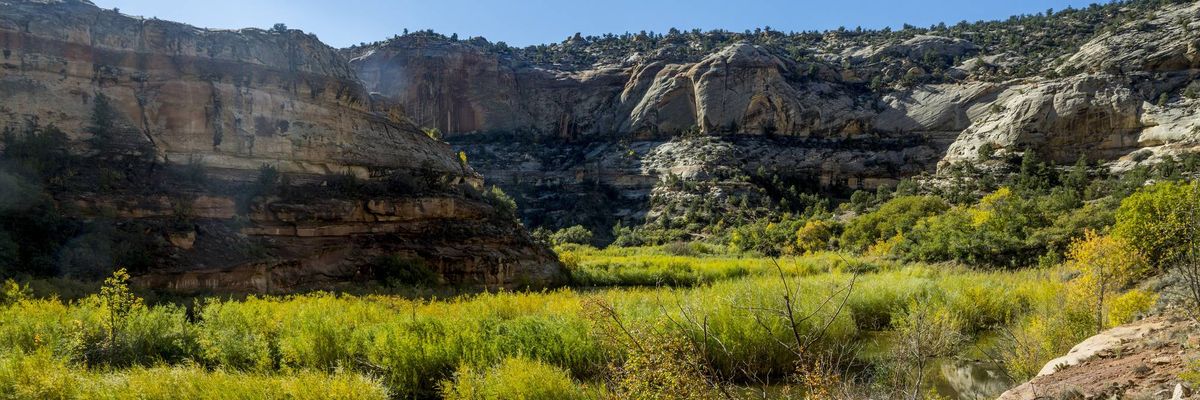
US President Donald Trump on Monday signed proclamations dramatically shrinking the size of two national monuments in Utah, eliminating roughly 3 million acres of protections for Bears Ears and Grand Staircase-Escalante and potentially opening the beloved, wildlife-rich areas to industry exploitation.
Trump's proclamations, issued at the urging of Utah Republicans including Sen. Mike Lee, aim to reduce Bears Ears to just under 121,100 acres (down from nearly 1.4 million) and Grand Staircase-Escalante to 181,541 acres (down from 1.87 million). The president declared in his orders—which opponents say are unlawful—that the areas he's stripping of their monument designation contain "several resources that are vital to energy and resource independence," including silver, copper, uranium, and zinc.
The orders were met with immediate outrage from tribes, Democratic lawmakers, and conservationists. Rep. Jared Huffman (D-Calif.), the top Democrat on the House Natural Resources Committee, said in a statement that the president has "illegally opened up two of the most extraordinary landscapes in America at the behest of polluting corporations who seek to ravage them for short-term profits."
"Trump has been selling out our public lands and waters since the day he took office," said Huffman, pointing to previous attacks on the monuments during the president's first White House term. "Trump tried this once before. We fought him then, and we are ready to fight him now, because no president should have the power to give away what belongs to the American people, including future generations. Keep public lands in public hands.”
Scott Braden, executive director of the Southern Utah Wilderness Alliance, said his organization "will challenge this unlawful decision in federal court" and expressed confidence that Trump's "reckless and unlawful acts will be rejected."
“Today’s action makes it clear that Utah is the epicenter of Republican efforts to dismantle and obliterate America’s system of public lands," said Braden. "President Trump’s outrageous attack on Grand Staircase-Escalante and Bears Ears national monuments was taken at the urging of Utah politicians—Sens. Mike Lee and John Curtis, Gov. Spencer Cox, and the others—who championed this action. These two landscapes deserve to be protected for current and future generations of Utahns and Americans, not opened to exploitation."
During a signing ceremony on Monday, flanked by Utah Republicans, Trump characterized his scaling back of monument protections as an effort to give land "back to the people of Utah." The president falsely claimed that people could "virtually not even walk on" the lands under the protections he targeted.
"You can’t go hunting. You can’t go fishing," the president said, incorrectly. "You can’t do anything."
Trump's proclamations cite authority under the Antiquities Act of 1906, which empowers the president to "reserve parcels of land as a part of the national monuments." But opponents of Trump's assault on the two Utah national monuments noted that the law does not explicitly authorize the president to scale back protections implemented by previous administrations.
In 2021, then-President Joe Biden restored protections to Bears Ears and Grand Staircase-Escalante after Trump's first attempt to gut them in 2017. Trump's new assault on the two national monuments goes much further than the previous one. (The far-right Project 2025 agenda, which Trump has repeatedly tried to disavow despite his ties to its architects, called for the downsizing of national monuments and repeal of the Antiquities Act.)
"President Trump’s attack on Bears Ears and Grand Staircase-Escalante National Monuments is just as illegal today as it was in 2017,” Heidi McIntosh, managing attorney for Earthjustice’s Rocky Mountain Office, said in a statement on Monday. "The Antiquities Act authorizes presidents to designate national monuments, not to destroy them. Today’s proclamations are a slap to the face of public lands visitors across the country, as well as the local communities and tribes that have worked for years to protect these special places. Earthjustice and our partners are prepared to vigorously defend the monuments once again."
Autumn Gillard, coordinator for the Grand Staircase-Escalante Inter-Tribal Coalition, said Monday that "our tribes were not informed of or asked about this decision, and that’s unacceptable."
“Today’s action is a direct strike against the federal government’s duty to consult with tribes," said Gillard. "It also profoundly disrespects our intergenerational traditional knowledge by destroying a framework for tribal co-stewardship over our ancestral lands in which we invested years of effort. Today’s action cannot stand."
From Common Dreams via This RSS Feed.
24
Indigenous and Climate Campaigners Decry 'Deep Betrayal' as Michigan Issues Key Enbridge Line 5 Permits | Common Dreams
(www.commondreams.org)
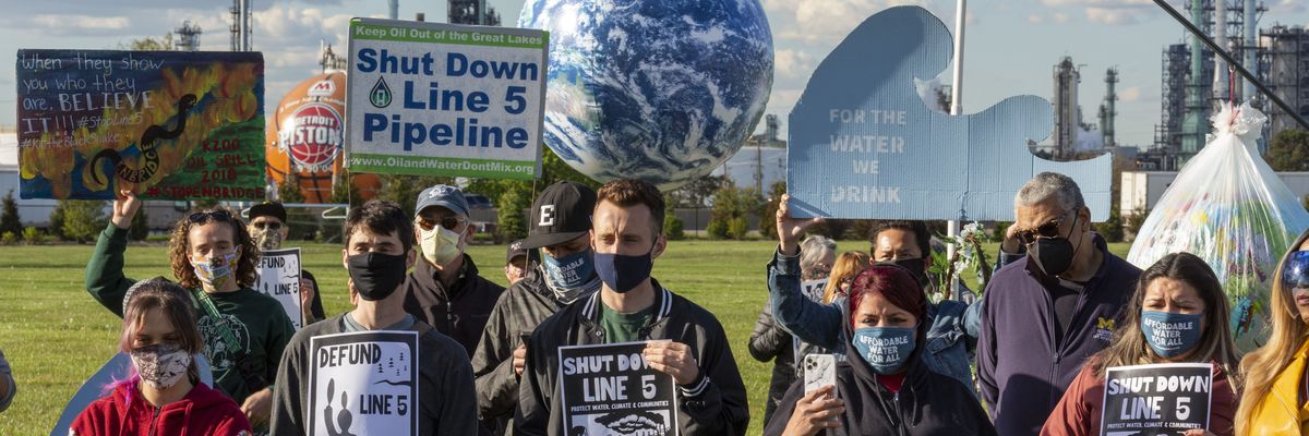
Anti-fossil fuel campaigners on Wednesday emphasized that Michigan state regulators had issued key permits for the Enbridge Line 5 tunnel in the Straits of Mackinac on the same day that "wildfire smoke from climate change blotted out the Mackinac Bridge from view" and as the US and other countries faced extreme heatwaves.
Despite the mounting evidence that—as energy and climate experts have long warned—continued fossil fuel extraction is heating the planet and causing dangerous extreme weather, Michigan's Department of Environment, Great Lakes, and Energy handed down a permit Wednesday to allow the Canadian company Enbridge to construct a tunnel that EGLE officials acknowledged will likely have "significant impacts" on threatened or endangered species and Indigenous burial ground in the Straits.
“The magnitude of impacts to recognized historic and cultural values of this proposed project exceeds that of any other that EGLE has reviewed,” said EGLE in its statement on the permits.
Enbridge has sought to build a tunnel around its Line 5 pipeline in the Straits for years, following a massive oil spill from its Line 6B pipeline in the Kalamazoo River. Line 5 has been struck by ships' anchors numerous times, heightening concerns.
EGLE said in its explanation that the oil spill risk was found to be "unacceptable" and that the need for the tunnel outweighed its risks.
But opponents who have argued that Line 5 should be permanently shut down, including the Bay Mills Indian Community, condemned the agency for "rewarding" Enbridge with new permits even after its fossil fuel infrastructure has caused hazardous oil spills.
“Enbridge has spilled oil, committed safety violations, trespassed on lands, shattered ecosystems, pierced aquifers, violated our laws, and repeatedly shown contempt for tribal sovereignty," said Whitney Gravelle, president of the Bay Mills Indian Community. "They have left devastation in their wake, and now they’re being rewarded with responsibility over one of the most precious and sacred resources in our state. The Great Lakes are not safe in their hands. This decision is a deep betrayal of our Great Lake State, and we will confront it immediately, fiercely, and without hesitation.”
The state Department of Natural Resources also issued a permit following EGLE's decision, granting permission for the tunnel despite its potential impact on rare plants and animal habitats.
According to Michigan Bridge, about 1.53 acres of wetlands in Mackinac County would be impacted by the tunnel project, as well as 0.17 acres of Lake Michigan bottomlands in Emmet County, where Enbridge is expected to build a water intake structure.
The environmental legal organization Earthjustice, which has helped represent the Bay Mills Indian Community in its legal challenges against Enbridge, said that with the permits, the company will "transform the Straits of Mackinac into an industrial construction zone for at least six years, destroying views, displacing wildlife, and interrupting tourism dollars."
“Our environmental laws, the looming climate crisis, and simple common sense tells us that an oil pipeline doesn’t belong in the Great Lakes,” said Earthjustice managing attorney Debbie Chizewer. “Today’s decision is a setback, but we’re not giving up. A future without oil in the Great Lakes is still possible.”
EGLE is also expected to rule by September 30 on an Enbridge request to discharge millions of gallons of treated wastewater per day into Lake Michigan while it is constructing the tunnel, and the Michigan Supreme Court is considering a lawsuit brought by four Tribal Nations, including Bay Mills, alleging that the Michigan Public Service Commission improperly issued a key tunnel permit in 2023.
The state is also fighting Enbridge over Democratic Gov. Gretchen Whitmer's 2020 order to shut down Line 5 over oil spill concerns. She had campaigned in 2018 on a promise to shut down the pipeline. A federal judge ruled last year that the state had no authority to terminate the use of the pipeline, and the state appealed that ruling.
Advocates expressed anger on Wednesday at Whitmer as her government issued the permits.
“It’s incredibly disappointing that a governor who ran on a commitment to the climate and protecting the Great Lakes has now decided to instead endorse a Canadian industrial tunnel project that still threatens the Great Lakes and will contribute fossil fuels to the climate,” David Holtz, coalition coordinator for the anti-Line 5 group Oil & Water Don’t Mix, told Bridge Michigan.
David Gover, managing attorney for the Native American Rights Fund, said that "the Straits of Mackinac are not a piece of Enbridge oil infrastructure; they are the heart of creation for Anishinaabe people and a vital source of life for all who depend on the Great Lakes."
“We will pursue every legal avenue," Gover said, "to defend treaty rights, protect drinking water, and preserve tribal lifeways from another Enbridge disaster.”
From Common Dreams via This RSS Feed.
25
view more:
next ›